You are here: Home > Network List > TA - USArray Transportable Network (new EarthScope stations) Stations List
> Station L20A Wamsutter, WY, USA > Earthquake Result Viewer
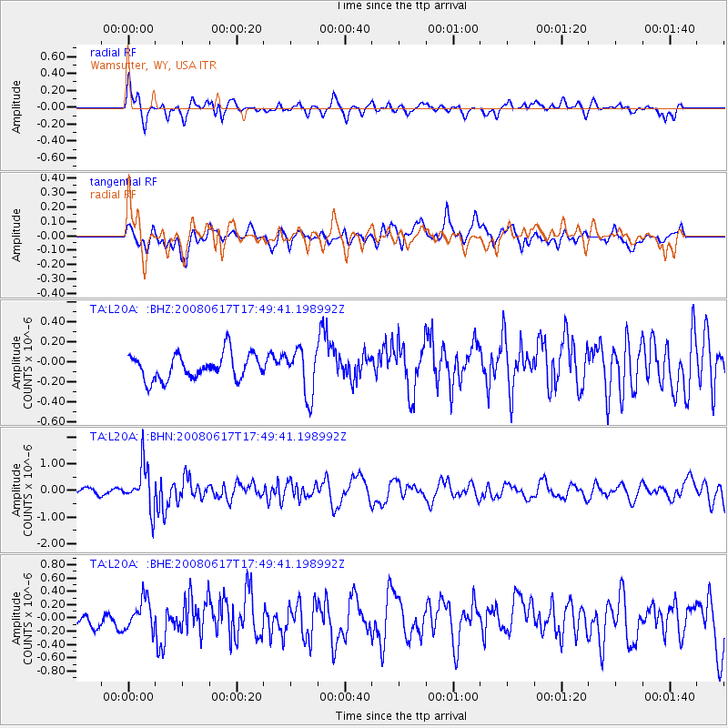
L20A Wamsutter, WY, USA - Earthquake Result Viewer
*The percent match for this event was below the threshold and hence no stack was calculated.
| Earthquake location: |
South Of Panama |
| Earthquake latitude/longitude: |
5.0/-82.7 |
| Earthquake time(UTC): |
2008/06/17 (169) 17:42:09 GMT |
| Earthquake Depth: |
10 km |
| Earthquake Magnitude: |
5.6 MB, 5.3 MS, 5.9 MW, 5.9 MW |
| Earthquake Catalog/Contributor: |
WHDF/NEIC |
|
| Network: |
TA USArray Transportable Network (new EarthScope stations) |
| Station: |
L20A Wamsutter, WY, USA |
| Lat/Lon: |
42.01 N/108.34 W |
| Elevation: |
2028 m |
|
| Distance: |
43.4 deg |
| Az: |
331.937 deg |
| Baz: |
141.036 deg |
| Ray Param: |
$rayparam |
*The percent match for this event was below the threshold and hence was not used in the summary stack. |
|
| Radial Match: |
72.519714 % |
| Radial Bump: |
400 |
| Transverse Match: |
63.567802 % |
| Transverse Bump: |
400 |
| SOD ConfigId: |
2504 |
| Insert Time: |
2010-03-06 22:37:47.825 +0000 |
| GWidth: |
2.5 |
| Max Bumps: |
400 |
| Tol: |
0.001 |
|
Signal To Noise
| Channel | StoN | STA | LTA |
| TA:L20A: :BHN:20080617T17:49:41.198992Z | 10.473028 | 8.239449E-7 | 7.867303E-8 |
| TA:L20A: :BHE:20080617T17:49:41.198992Z | 2.1031497 | 2.4504735E-7 | 1.1651445E-7 |
| TA:L20A: :BHZ:20080617T17:49:41.198992Z | 1.8658099 | 2.3370265E-7 | 1.2525533E-7 |
| Arrivals |
| Ps | |
| PpPs | |
| PsPs/PpSs | |


