You are here: Home > Network List > TA - USArray Transportable Network (new EarthScope stations) Stations List
> Station L20A Wamsutter, WY, USA > Earthquake Result Viewer
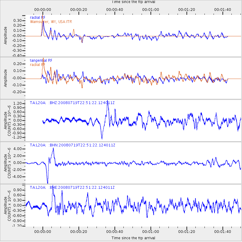
L20A Wamsutter, WY, USA - Earthquake Result Viewer
*The percent match for this event was below the threshold and hence no stack was calculated.
| Earthquake location: |
Fiji Islands Region |
| Earthquake latitude/longitude: |
-17.3/-177.3 |
| Earthquake time(UTC): |
2008/07/19 (201) 22:39:52 GMT |
| Earthquake Depth: |
391 km |
| Earthquake Magnitude: |
5.9 MB, 6.4 MW, 6.4 MW |
| Earthquake Catalog/Contributor: |
WHDF/NEIC |
|
| Network: |
TA USArray Transportable Network (new EarthScope stations) |
| Station: |
L20A Wamsutter, WY, USA |
| Lat/Lon: |
42.01 N/108.34 W |
| Elevation: |
2028 m |
|
| Distance: |
86.7 deg |
| Az: |
44.173 deg |
| Baz: |
243.256 deg |
| Ray Param: |
$rayparam |
*The percent match for this event was below the threshold and hence was not used in the summary stack. |
|
| Radial Match: |
76.334366 % |
| Radial Bump: |
400 |
| Transverse Match: |
73.88331 % |
| Transverse Bump: |
400 |
| SOD ConfigId: |
2504 |
| Insert Time: |
2010-03-06 22:37:50.777 +0000 |
| GWidth: |
2.5 |
| Max Bumps: |
400 |
| Tol: |
0.001 |
|
Signal To Noise
| Channel | StoN | STA | LTA |
| TA:L20A: :BHN:20080719T22:51:22.124011Z | 19.309965 | 2.076433E-6 | 1.0753169E-7 |
| TA:L20A: :BHE:20080719T22:51:22.124011Z | 2.170184 | 2.3861418E-7 | 1.0995114E-7 |
| TA:L20A: :BHZ:20080719T22:51:22.124011Z | 5.4484735 | 5.296455E-7 | 9.720989E-8 |
| Arrivals |
| Ps | |
| PpPs | |
| PsPs/PpSs | |


