You are here: Home > Network List > IU - Global Seismograph Network (GSN - IRIS/USGS) Stations List
> Station RSSD Black Hills, South Dakota, USA > Earthquake Result Viewer
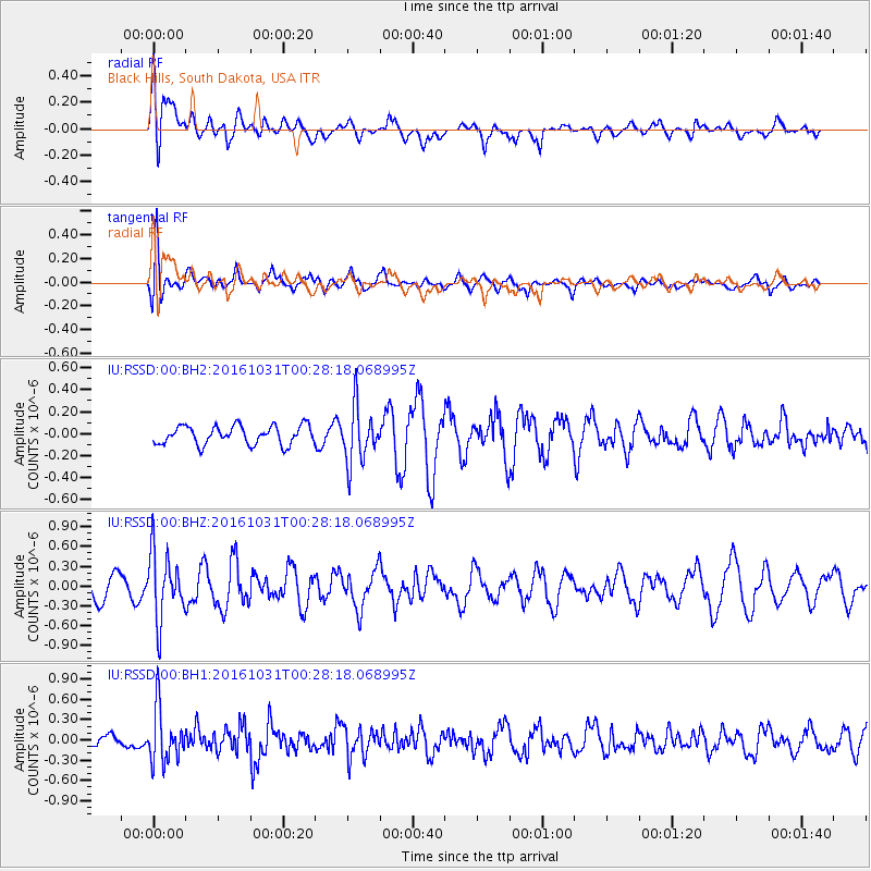
RSSD Black Hills, South Dakota, USA - Earthquake Result Viewer
*The percent match for this event was below the threshold and hence no stack was calculated.
| Earthquake location: |
Colombia |
| Earthquake latitude/longitude: |
3.4/-74.5 |
| Earthquake time(UTC): |
2016/10/31 (305) 00:20:11 GMT |
| Earthquake Depth: |
33 km |
| Earthquake Magnitude: |
5.6 MWW, 5.4 MWB |
| Earthquake Catalog/Contributor: |
NEIC PDE/NEIC COMCAT |
|
| Network: |
IU Global Seismograph Network (GSN - IRIS/USGS) |
| Station: |
RSSD Black Hills, South Dakota, USA |
| Lat/Lon: |
44.12 N/104.04 W |
| Elevation: |
2090 m |
|
| Distance: |
48.2 deg |
| Az: |
331.547 deg |
| Baz: |
138.672 deg |
| Ray Param: |
$rayparam |
*The percent match for this event was below the threshold and hence was not used in the summary stack. |
|
| Radial Match: |
64.69803 % |
| Radial Bump: |
400 |
| Transverse Match: |
65.35004 % |
| Transverse Bump: |
400 |
| SOD ConfigId: |
1815711 |
| Insert Time: |
2016-11-14 00:21:44.279 +0000 |
| GWidth: |
2.5 |
| Max Bumps: |
400 |
| Tol: |
0.001 |
|
Signal To Noise
| Channel | StoN | STA | LTA |
| IU:RSSD:00:BHZ:20161031T00:28:18.068995Z | 3.2382095 | 5.0564546E-7 | 1.561497E-7 |
| IU:RSSD:00:BH1:20161031T00:28:18.068995Z | 4.81741 | 3.984719E-7 | 8.271497E-8 |
| IU:RSSD:00:BH2:20161031T00:28:18.068995Z | 2.9853485 | 2.5170368E-7 | 8.4313E-8 |
| Arrivals |
| Ps | |
| PpPs | |
| PsPs/PpSs | |


