You are here: Home > Network List > TA - USArray Transportable Network (new EarthScope stations) Stations List
> Station L20A Wamsutter, WY, USA > Earthquake Result Viewer
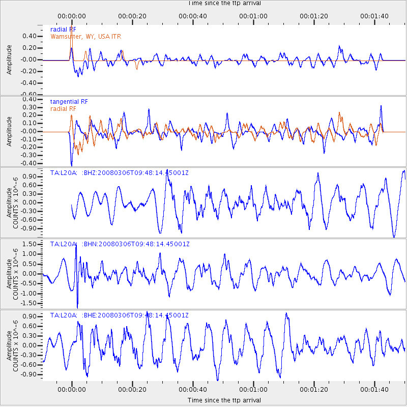
L20A Wamsutter, WY, USA - Earthquake Result Viewer
*The percent match for this event was below the threshold and hence no stack was calculated.
| Earthquake location: |
Kamchatka Peninsula, Russia |
| Earthquake latitude/longitude: |
51.5/156.5 |
| Earthquake time(UTC): |
2008/03/06 (066) 09:38:43 GMT |
| Earthquake Depth: |
134 km |
| Earthquake Magnitude: |
5.6 MB, 5.5 MW, 5.5 MW |
| Earthquake Catalog/Contributor: |
WHDF/NEIC |
|
| Network: |
TA USArray Transportable Network (new EarthScope stations) |
| Station: |
L20A Wamsutter, WY, USA |
| Lat/Lon: |
42.01 N/108.34 W |
| Elevation: |
2028 m |
|
| Distance: |
61.4 deg |
| Az: |
57.746 deg |
| Baz: |
314.851 deg |
| Ray Param: |
$rayparam |
*The percent match for this event was below the threshold and hence was not used in the summary stack. |
|
| Radial Match: |
46.656353 % |
| Radial Bump: |
383 |
| Transverse Match: |
62.797592 % |
| Transverse Bump: |
400 |
| SOD ConfigId: |
2504 |
| Insert Time: |
2010-03-06 22:38:53.785 +0000 |
| GWidth: |
2.5 |
| Max Bumps: |
400 |
| Tol: |
0.001 |
|
Signal To Noise
| Channel | StoN | STA | LTA |
| TA:L20A: :BHN:20080306T09:48:14.45001Z | 2.2416239 | 7.16097E-7 | 3.1945459E-7 |
| TA:L20A: :BHE:20080306T09:48:14.45001Z | 1.75776 | 4.5033596E-7 | 2.5619877E-7 |
| TA:L20A: :BHZ:20080306T09:48:14.45001Z | 2.3376355 | 6.811405E-7 | 2.913801E-7 |
| Arrivals |
| Ps | |
| PpPs | |
| PsPs/PpSs | |


