You are here: Home > Network List > TA - USArray Transportable Network (new EarthScope stations) Stations List
> Station L20A Wamsutter, WY, USA > Earthquake Result Viewer
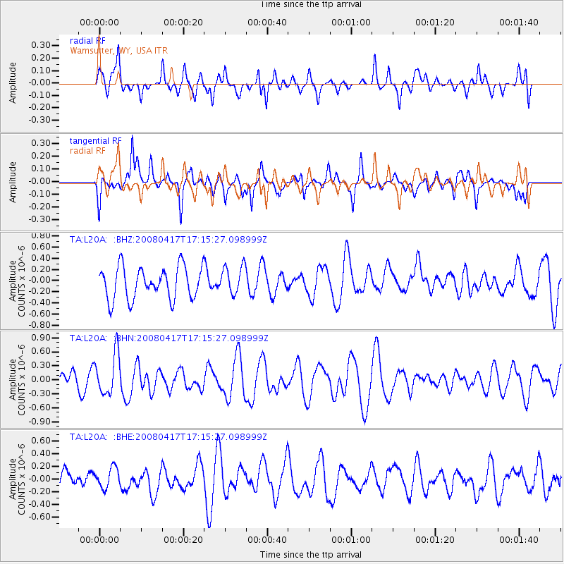
L20A Wamsutter, WY, USA - Earthquake Result Viewer
*The percent match for this event was below the threshold and hence no stack was calculated.
| Earthquake location: |
Mariana Islands Region |
| Earthquake latitude/longitude: |
15.9/144.9 |
| Earthquake time(UTC): |
2008/04/17 (108) 17:02:52 GMT |
| Earthquake Depth: |
10 km |
| Earthquake Magnitude: |
5.5 MB, 5.2 MS, 5.5 MW, 5.5 MW |
| Earthquake Catalog/Contributor: |
WHDF/NEIC |
|
| Network: |
TA USArray Transportable Network (new EarthScope stations) |
| Station: |
L20A Wamsutter, WY, USA |
| Lat/Lon: |
42.01 N/108.34 W |
| Elevation: |
2028 m |
|
| Distance: |
91.5 deg |
| Az: |
45.544 deg |
| Baz: |
292.837 deg |
| Ray Param: |
$rayparam |
*The percent match for this event was below the threshold and hence was not used in the summary stack. |
|
| Radial Match: |
62.15046 % |
| Radial Bump: |
400 |
| Transverse Match: |
55.057865 % |
| Transverse Bump: |
400 |
| SOD ConfigId: |
2504 |
| Insert Time: |
2010-03-06 22:38:57.664 +0000 |
| GWidth: |
2.5 |
| Max Bumps: |
400 |
| Tol: |
0.001 |
|
Signal To Noise
| Channel | StoN | STA | LTA |
| TA:L20A: :BHN:20080417T17:15:27.098999Z | 2.1350005 | 4.473238E-7 | 2.0951931E-7 |
| TA:L20A: :BHE:20080417T17:15:27.098999Z | 0.69272345 | 1.5993268E-7 | 2.3087522E-7 |
| TA:L20A: :BHZ:20080417T17:15:27.098999Z | 0.9003102 | 2.5922154E-7 | 2.8792468E-7 |
| Arrivals |
| Ps | |
| PpPs | |
| PsPs/PpSs | |


