You are here: Home > Network List > TA - USArray Transportable Network (new EarthScope stations) Stations List
> Station G31M Satah River, YT, CAN > Earthquake Result Viewer
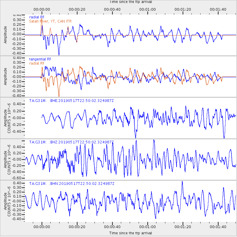
G31M Satah River, YT, CAN - Earthquake Result Viewer
*The percent match for this event was below the threshold and hence no stack was calculated.
| Earthquake location: |
New Ireland Region, P.N.G. |
| Earthquake latitude/longitude: |
-4.6/153.0 |
| Earthquake time(UTC): |
2019/05/17 (137) 22:37:47 GMT |
| Earthquake Depth: |
21 km |
| Earthquake Magnitude: |
5.9 Mww |
| Earthquake Catalog/Contributor: |
NEIC PDE/us |
|
| Network: |
TA USArray Transportable Network (new EarthScope stations) |
| Station: |
G31M Satah River, YT, CAN |
| Lat/Lon: |
66.92 N/134.27 W |
| Elevation: |
61 m |
|
| Distance: |
87.5 deg |
| Az: |
22.134 deg |
| Baz: |
252.319 deg |
| Ray Param: |
$rayparam |
*The percent match for this event was below the threshold and hence was not used in the summary stack. |
|
| Radial Match: |
66.199005 % |
| Radial Bump: |
400 |
| Transverse Match: |
59.450634 % |
| Transverse Bump: |
400 |
| SOD ConfigId: |
18369291 |
| Insert Time: |
2019-05-31 22:41:24.810 +0000 |
| GWidth: |
2.5 |
| Max Bumps: |
400 |
| Tol: |
0.001 |
|
Signal To Noise
| Channel | StoN | STA | LTA |
| TA:G31M: :BHZ:20190517T22:50:02.324987Z | 2.5751762 | 1.7814851E-7 | 6.917915E-8 |
| TA:G31M: :BHN:20190517T22:50:02.324987Z | 1.0597596 | 1.2398544E-7 | 1.1699393E-7 |
| TA:G31M: :BHE:20190517T22:50:02.324987Z | 0.94819033 | 1.2573739E-7 | 1.3260775E-7 |
| Arrivals |
| Ps | |
| PpPs | |
| PsPs/PpSs | |


