You are here: Home > Network List > US - United States National Seismic Network Stations List
> Station AMTX Amarillo, Texas, USA > Earthquake Result Viewer
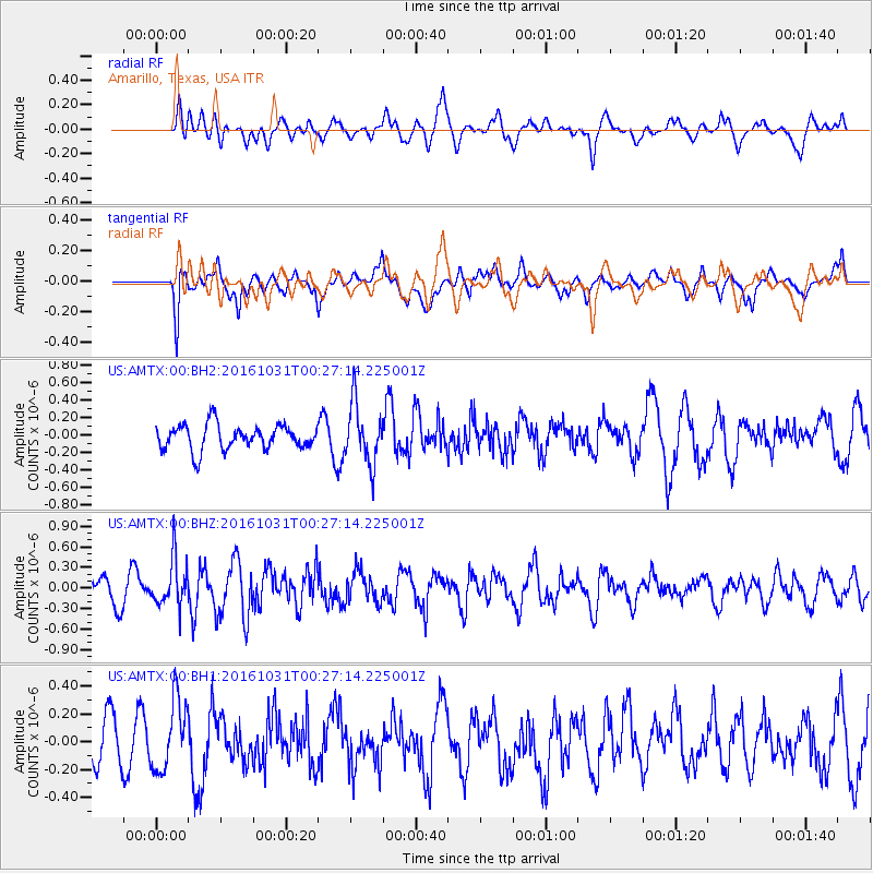
AMTX Amarillo, Texas, USA - Earthquake Result Viewer
*The percent match for this event was below the threshold and hence no stack was calculated.
| Earthquake location: |
Colombia |
| Earthquake latitude/longitude: |
3.4/-74.5 |
| Earthquake time(UTC): |
2016/10/31 (305) 00:20:11 GMT |
| Earthquake Depth: |
33 km |
| Earthquake Magnitude: |
5.6 MWW, 5.4 MWB |
| Earthquake Catalog/Contributor: |
NEIC PDE/NEIC COMCAT |
|
| Network: |
US United States National Seismic Network |
| Station: |
AMTX Amarillo, Texas, USA |
| Lat/Lon: |
34.53 N/101.41 W |
| Elevation: |
1010 m |
|
| Distance: |
39.8 deg |
| Az: |
324.271 deg |
| Baz: |
135.084 deg |
| Ray Param: |
$rayparam |
*The percent match for this event was below the threshold and hence was not used in the summary stack. |
|
| Radial Match: |
58.060978 % |
| Radial Bump: |
400 |
| Transverse Match: |
52.830208 % |
| Transverse Bump: |
400 |
| SOD ConfigId: |
1815711 |
| Insert Time: |
2016-11-14 00:22:46.562 +0000 |
| GWidth: |
2.5 |
| Max Bumps: |
400 |
| Tol: |
0.001 |
|
Signal To Noise
| Channel | StoN | STA | LTA |
| US:AMTX:00:BHZ:20161031T00:27:14.225001Z | 1.5150018 | 3.4320504E-7 | 2.2653772E-7 |
| US:AMTX:00:BH1:20161031T00:27:14.225001Z | 1.0542117 | 2.5131635E-7 | 2.3839266E-7 |
| US:AMTX:00:BH2:20161031T00:27:14.225001Z | 2.2881055 | 3.4016006E-7 | 1.4866451E-7 |
| Arrivals |
| Ps | |
| PpPs | |
| PsPs/PpSs | |


