You are here: Home > Network List > US - United States National Seismic Network Stations List
> Station EGMT Eagleton, Montana, USA > Earthquake Result Viewer
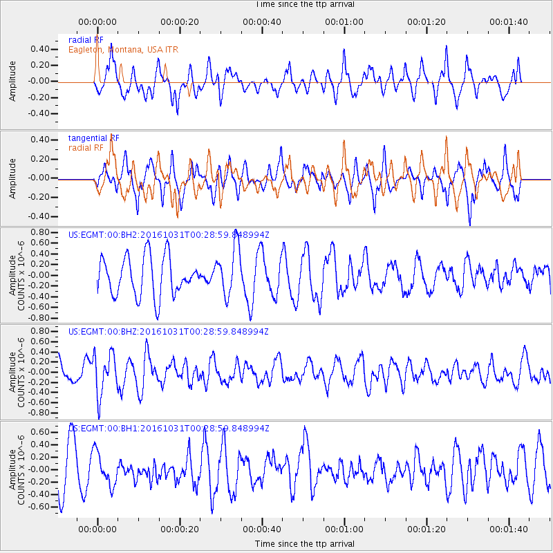
EGMT Eagleton, Montana, USA - Earthquake Result Viewer
*The percent match for this event was below the threshold and hence no stack was calculated.
| Earthquake location: |
Colombia |
| Earthquake latitude/longitude: |
3.4/-74.5 |
| Earthquake time(UTC): |
2016/10/31 (305) 00:20:11 GMT |
| Earthquake Depth: |
33 km |
| Earthquake Magnitude: |
5.6 MWW, 5.4 MWB |
| Earthquake Catalog/Contributor: |
NEIC PDE/NEIC COMCAT |
|
| Network: |
US United States National Seismic Network |
| Station: |
EGMT Eagleton, Montana, USA |
| Lat/Lon: |
48.02 N/109.75 W |
| Elevation: |
1055 m |
|
| Distance: |
53.8 deg |
| Az: |
331.281 deg |
| Baz: |
134.394 deg |
| Ray Param: |
$rayparam |
*The percent match for this event was below the threshold and hence was not used in the summary stack. |
|
| Radial Match: |
58.35136 % |
| Radial Bump: |
400 |
| Transverse Match: |
62.951088 % |
| Transverse Bump: |
400 |
| SOD ConfigId: |
1815711 |
| Insert Time: |
2016-11-14 00:22:56.467 +0000 |
| GWidth: |
2.5 |
| Max Bumps: |
400 |
| Tol: |
0.001 |
|
Signal To Noise
| Channel | StoN | STA | LTA |
| US:EGMT:00:BHZ:20161031T00:28:59.848994Z | 2.348056 | 4.151199E-7 | 1.7679301E-7 |
| US:EGMT:00:BH1:20161031T00:28:59.848994Z | 0.87346226 | 2.6528468E-7 | 3.0371626E-7 |
| US:EGMT:00:BH2:20161031T00:28:59.848994Z | 1.300078 | 4.6969976E-7 | 3.6128583E-7 |
| Arrivals |
| Ps | |
| PpPs | |
| PsPs/PpSs | |


