You are here: Home > Network List > TA - USArray Transportable Network (new EarthScope stations) Stations List
> Station I18A Diamond G Ranch, Dubois, WY, USA > Earthquake Result Viewer
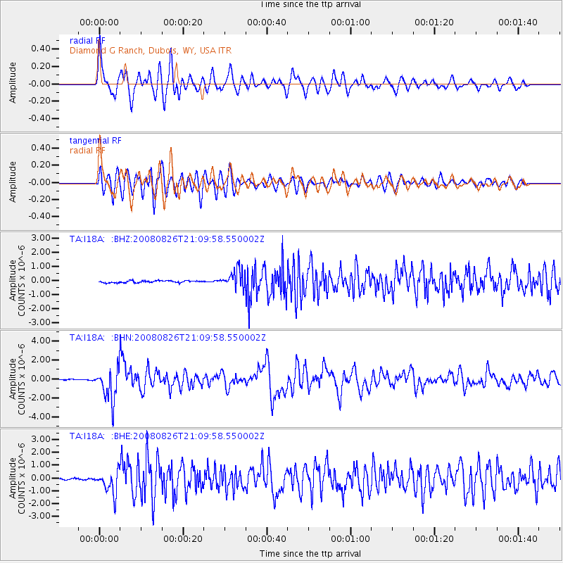
I18A Diamond G Ranch, Dubois, WY, USA - Earthquake Result Viewer

| Earthquake location: |
Peru-Brazil Border Region |
| Earthquake latitude/longitude: |
-7.6/-74.4 |
| Earthquake time(UTC): |
2008/08/26 (239) 21:00:36 GMT |
| Earthquake Depth: |
154 km |
| Earthquake Magnitude: |
6.0 MB, 6.4 MW, 6.4 MW |
| Earthquake Catalog/Contributor: |
WHDF/NEIC |
|
| Network: |
TA USArray Transportable Network (new EarthScope stations) |
| Station: |
I18A Diamond G Ranch, Dubois, WY, USA |
| Lat/Lon: |
43.70 N/109.82 W |
| Elevation: |
2322 m |
|
| Distance: |
60.3 deg |
| Az: |
331.058 deg |
| Baz: |
138.593 deg |
| Ray Param: |
0.06111727 |
| Estimated Moho Depth: |
36.0 km |
| Estimated Crust Vp/Vs: |
2.06 |
| Assumed Crust Vp: |
6.161 km/s |
| Estimated Crust Vs: |
2.994 km/s |
| Estimated Crust Poisson's Ratio: |
0.35 |
|
| Radial Match: |
80.0903 % |
| Radial Bump: |
400 |
| Transverse Match: |
72.28719 % |
| Transverse Bump: |
400 |
| SOD ConfigId: |
2504 |
| Insert Time: |
2010-03-06 22:39:37.183 +0000 |
| GWidth: |
2.5 |
| Max Bumps: |
400 |
| Tol: |
0.001 |
|
Signal To Noise
| Channel | StoN | STA | LTA |
| TA:I18A: :BHN:20080826T21:09:58.550002Z | 43.703003 | 1.7631094E-6 | 4.034298E-8 |
| TA:I18A: :BHE:20080826T21:09:58.550002Z | 15.09876 | 9.085316E-7 | 6.01726E-8 |
| TA:I18A: :BHZ:20080826T21:09:58.550002Z | 9.407152 | 6.3782176E-7 | 6.780179E-8 |
| Arrivals |
| Ps | 6.4 SECOND |
| PpPs | 17 SECOND |
| PsPs/PpSs | 24 SECOND |


