You are here: Home > Network List > TA - USArray Transportable Network (new EarthScope stations) Stations List
> Station I18A Diamond G Ranch, Dubois, WY, USA > Earthquake Result Viewer
I18A Diamond G Ranch, Dubois, WY, USA - Earthquake Result Viewer
| Earthquake location: |
Tonga Islands |
| Earthquake latitude/longitude: |
-21.9/-173.8 |
| Earthquake time(UTC): |
2008/10/19 (293) 05:10:33 GMT |
| Earthquake Depth: |
29 km |
| Earthquake Magnitude: |
6.8 MB, 7.0 MS, 6.9 MW, 6.9 MW |
| Earthquake Catalog/Contributor: |
WHDF/NEIC |
|
| Network: |
TA USArray Transportable Network (new EarthScope stations) |
| Station: |
I18A Diamond G Ranch, Dubois, WY, USA |
| Lat/Lon: |
43.70 N/109.82 W |
| Elevation: |
2322 m |
|
| Distance: |
87.7 deg |
| Az: |
40.723 deg |
| Baz: |
236.68 deg |
| Ray Param: |
0.04311259 |
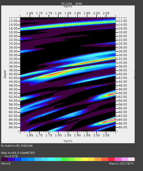
| Estimated Moho Depth: |
64.0 km |
| Estimated Crust Vp/Vs: |
2.08 |
| Assumed Crust Vp: |
6.161 km/s |
| Estimated Crust Vs: |
2.969 km/s |
| Estimated Crust Poisson's Ratio: |
0.35 |
|
| Radial Match: |
91.948166 % |
| Radial Bump: |
400 |
| Transverse Match: |
85.59022 % |
| Transverse Bump: |
400 |
| SOD ConfigId: |
2556 |
| Insert Time: |
2010-03-06 22:39:41.053 +0000 |
| GWidth: |
2.5 |
| Max Bumps: |
400 |
| Tol: |
0.001 |
|
Signal To Noise
| Channel | StoN | STA | LTA |
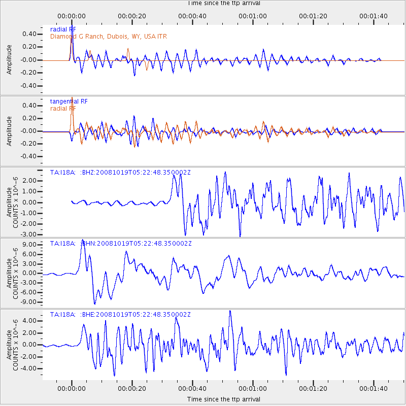
| TA:I18A: :BHN:20081019T05:22:48.350002Z | 36.241413 | 5.0174262E-6 | 1.3844455E-7 |
| TA:I18A: :BHE:20081019T05:22:48.350002Z | 10.070015 | 1.48887E-6 | 1.4785182E-7 |
| TA:I18A: :BHZ:20081019T05:22:48.350002Z | 9.243371 | 1.1561597E-6 | 1.2507988E-7 |
| Arrivals |
| Ps | 11 SECOND |
| PpPs | 31 SECOND |
| PsPs/PpSs | 43 SECOND |


