You are here: Home > Network List > TA - USArray Transportable Network (new EarthScope stations) Stations List
> Station I18A Diamond G Ranch, Dubois, WY, USA > Earthquake Result Viewer
I18A Diamond G Ranch, Dubois, WY, USA - Earthquake Result Viewer
| Earthquake location: |
Central Mid-Atlantic Ridge |
| Earthquake latitude/longitude: |
8.1/-38.7 |
| Earthquake time(UTC): |
2008/09/10 (254) 13:08:14 GMT |
| Earthquake Depth: |
10 km |
| Earthquake Magnitude: |
6.3 MB, 6.5 MS, 6.6 MW, 6.6 MW |
| Earthquake Catalog/Contributor: |
WHDF/NEIC |
|
| Network: |
TA USArray Transportable Network (new EarthScope stations) |
| Station: |
I18A Diamond G Ranch, Dubois, WY, USA |
| Lat/Lon: |
43.70 N/109.82 W |
| Elevation: |
2322 m |
|
| Distance: |
70.8 deg |
| Az: |
313.399 deg |
| Baz: |
97.264 deg |
| Ray Param: |
0.054744434 |
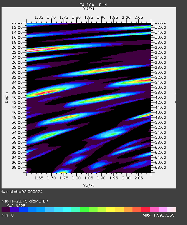
| Estimated Moho Depth: |
20.75 km |
| Estimated Crust Vp/Vs: |
1.63 |
| Assumed Crust Vp: |
6.161 km/s |
| Estimated Crust Vs: |
3.774 km/s |
| Estimated Crust Poisson's Ratio: |
0.20 |
|
| Radial Match: |
93.000824 % |
| Radial Bump: |
400 |
| Transverse Match: |
81.71964 % |
| Transverse Bump: |
400 |
| SOD ConfigId: |
2560 |
| Insert Time: |
2010-03-06 22:39:43.359 +0000 |
| GWidth: |
2.5 |
| Max Bumps: |
400 |
| Tol: |
0.001 |
|

Signal To Noise
| Channel | StoN | STA | LTA |
| TA:I18A: :BHN:20080910T13:19:00.199001Z | 4.5286484 | 4.6769986E-7 | 1.03275816E-7 |
| TA:I18A: :BHE:20080910T13:19:00.199001Z | 1.166347 | 1.0245532E-7 | 8.7842906E-8 |
| TA:I18A: :BHZ:20080910T13:19:00.199001Z | 2.3912842 | 1.9694991E-7 | 8.236157E-8 |
| Arrivals |
| Ps | 2.2 SECOND |
| PpPs | 8.6 SECOND |
| PsPs/PpSs | 11 SECOND |


