You are here: Home > Network List > TA - USArray Transportable Network (new EarthScope stations) Stations List
> Station I18A Diamond G Ranch, Dubois, WY, USA > Earthquake Result Viewer
I18A Diamond G Ranch, Dubois, WY, USA - Earthquake Result Viewer
| Earthquake location: |
Andreanof Islands, Aleutian Is. |
| Earthquake latitude/longitude: |
51.4/-179.5 |
| Earthquake time(UTC): |
2007/12/19 (353) 09:30:27 GMT |
| Earthquake Depth: |
29 km |
| Earthquake Magnitude: |
6.4 MB, 7.1 MS, 7.1 MW, 7.0 MW |
| Earthquake Catalog/Contributor: |
WHDF/NEIC |
|
| Network: |
TA USArray Transportable Network (new EarthScope stations) |
| Station: |
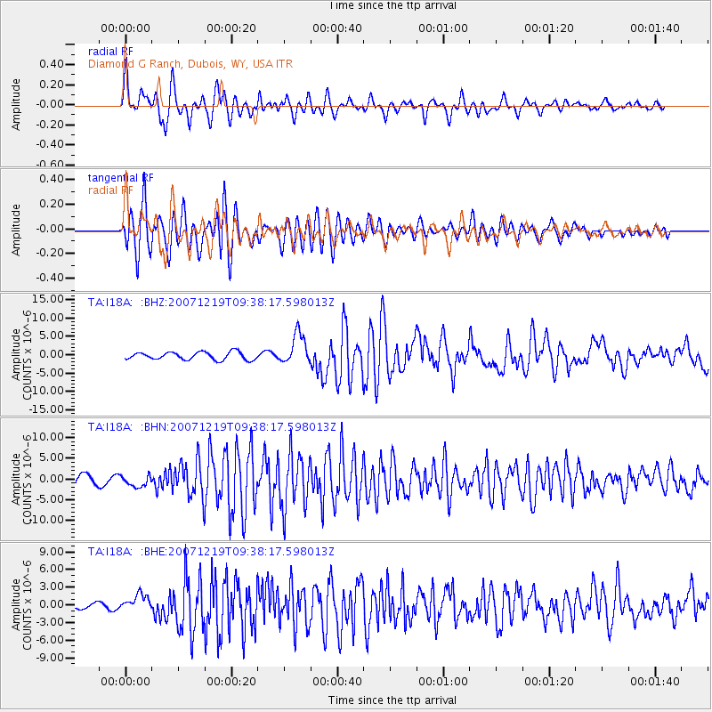
I18A Diamond G Ranch, Dubois, WY, USA |
| Lat/Lon: |
43.70 N/109.82 W |
| Elevation: |
2322 m |
|
| Distance: |
46.0 deg |
| Az: |
70.893 deg |
| Baz: |
305.233 deg |
| Ray Param: |
0.07083438 |
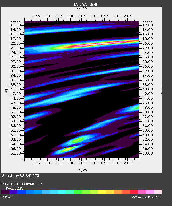
| Estimated Moho Depth: |
20.0 km |
| Estimated Crust Vp/Vs: |
1.92 |
| Assumed Crust Vp: |
6.161 km/s |
| Estimated Crust Vs: |
3.205 km/s |
| Estimated Crust Poisson's Ratio: |
0.31 |
|
| Radial Match: |
88.341675 % |
| Radial Bump: |
400 |
| Transverse Match: |
87.10741 % |
| Transverse Bump: |
400 |
| SOD ConfigId: |
2564 |
| Insert Time: |
2010-03-06 22:40:08.185 +0000 |
| GWidth: |
2.5 |
| Max Bumps: |
400 |
| Tol: |
0.001 |
|
Signal To Noise
| Channel | StoN | STA | LTA |
| TA:I18A: :BHN:20071219T09:38:17.598013Z | 1.025605 | 1.3390187E-6 | 1.3055891E-6 |
| TA:I18A: :BHE:20071219T09:38:17.598013Z | 3.2783446 | 1.3926729E-6 | 4.2480977E-7 |
| TA:I18A: :BHZ:20071219T09:38:17.598013Z | 4.005208 | 4.2241104E-6 | 1.0546545E-6 |
| Arrivals |
| Ps | 3.2 SECOND |
| PpPs | 9.0 SECOND |
| PsPs/PpSs | 12 SECOND |


