You are here: Home > Network List > TA - USArray Transportable Network (new EarthScope stations) Stations List
> Station I18A Diamond G Ranch, Dubois, WY, USA > Earthquake Result Viewer
I18A Diamond G Ranch, Dubois, WY, USA - Earthquake Result Viewer
| Earthquake location: |
Mariana Islands |
| Earthquake latitude/longitude: |
18.9/145.4 |
| Earthquake time(UTC): |
2007/10/31 (304) 03:30:17 GMT |
| Earthquake Depth: |
223 km |
| Earthquake Magnitude: |
6.2 MB, 7.2 MW, 7.2 MW |
| Earthquake Catalog/Contributor: |
WHDF/NEIC |
|
| Network: |
TA USArray Transportable Network (new EarthScope stations) |
| Station: |
I18A Diamond G Ranch, Dubois, WY, USA |
| Lat/Lon: |
43.70 N/109.82 W |
| Elevation: |
2322 m |
|
| Distance: |
87.4 deg |
| Az: |
44.578 deg |
| Baz: |
293.617 deg |
| Ray Param: |
0.04284974 |
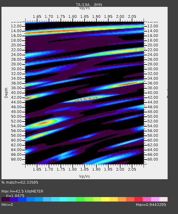
| Estimated Moho Depth: |
42.5 km |
| Estimated Crust Vp/Vs: |
1.85 |
| Assumed Crust Vp: |
6.161 km/s |
| Estimated Crust Vs: |
3.335 km/s |
| Estimated Crust Poisson's Ratio: |
0.29 |
|
| Radial Match: |
82.33595 % |
| Radial Bump: |
400 |
| Transverse Match: |
79.494675 % |
| Transverse Bump: |
400 |
| SOD ConfigId: |
2564 |
| Insert Time: |
2010-03-06 22:40:13.692 +0000 |
| GWidth: |
2.5 |
| Max Bumps: |
400 |
| Tol: |
0.001 |
|
Signal To Noise
| Channel | StoN | STA | LTA |
| TA:I18A: :BHN:20071031T03:42:08.024014Z | 1.2316418 | 2.7654988E-7 | 2.2453762E-7 |
| TA:I18A: :BHE:20071031T03:42:08.024014Z | 4.2074237 | 8.60488E-7 | 2.045166E-7 |
| TA:I18A: :BHZ:20071031T03:42:08.024014Z | 21.826302 | 3.3688848E-6 | 1.5434978E-7 |
| Arrivals |
| Ps | 6.0 SECOND |
| PpPs | 19 SECOND |
| PsPs/PpSs | 25 SECOND |


