You are here: Home > Network List > TA - USArray Transportable Network (new EarthScope stations) Stations List
> Station I18A Diamond G Ranch, Dubois, WY, USA > Earthquake Result Viewer
I18A Diamond G Ranch, Dubois, WY, USA - Earthquake Result Viewer

| Earthquake location: |
Rat Islands, Aleutian Islands |
| Earthquake latitude/longitude: |
50.4/177.0 |
| Earthquake time(UTC): |
2009/07/06 (187) 14:53:12 GMT |
| Earthquake Depth: |
22 km |
| Earthquake Magnitude: |
6.0 MB, 5.8 MS, 6.1 MW, 6.0 MW |
| Earthquake Catalog/Contributor: |
WHDF/NEIC |
|
| Network: |
TA USArray Transportable Network (new EarthScope stations) |
| Station: |
I18A Diamond G Ranch, Dubois, WY, USA |
| Lat/Lon: |
43.70 N/109.82 W |
| Elevation: |
2322 m |
|
| Distance: |
48.4 deg |
| Az: |
68.105 deg |
| Baz: |
305.101 deg |
| Ray Param: |
0.06932898 |
| Estimated Moho Depth: |
14.5 km |
| Estimated Crust Vp/Vs: |
1.73 |
| Assumed Crust Vp: |
6.161 km/s |
| Estimated Crust Vs: |
3.561 km/s |
| Estimated Crust Poisson's Ratio: |
0.25 |
|
| Radial Match: |
90.91947 % |
| Radial Bump: |
400 |
| Transverse Match: |
87.42955 % |
| Transverse Bump: |
400 |
| SOD ConfigId: |
2648 |
| Insert Time: |
2010-03-06 22:40:25.147 +0000 |
| GWidth: |
2.5 |
| Max Bumps: |
400 |
| Tol: |
0.001 |
|
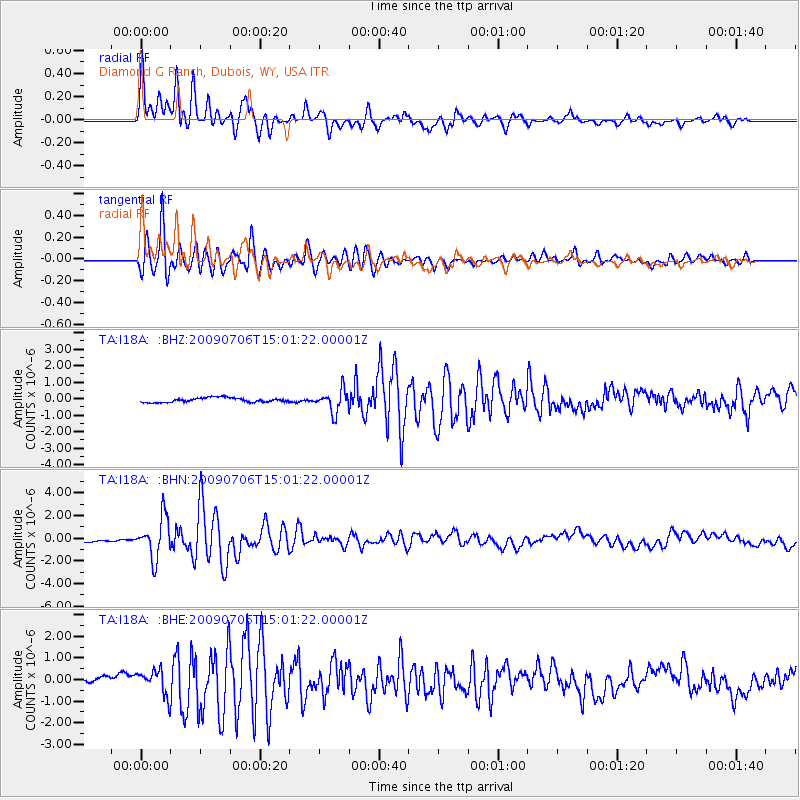
Signal To Noise
| Channel | StoN | STA | LTA |
| TA:I18A: :BHN:20090706T15:01:22.00001Z | 13.727127 | 1.7877577E-6 | 1.3023539E-7 |
| TA:I18A: :BHE:20090706T15:01:22.00001Z | 3.655934 | 5.670515E-7 | 1.551044E-7 |
| TA:I18A: :BHZ:20090706T15:01:22.00001Z | 4.9566627 | 6.630791E-7 | 1.3377532E-7 |
| Arrivals |
| Ps | 1.8 SECOND |
| PpPs | 6.1 SECOND |
| PsPs/PpSs | 7.9 SECOND |


