You are here: Home > Network List > TA - USArray Transportable Network (new EarthScope stations) Stations List
> Station I18A Diamond G Ranch, Dubois, WY, USA > Earthquake Result Viewer
I18A Diamond G Ranch, Dubois, WY, USA - Earthquake Result Viewer
| Earthquake location: |
Andreanof Islands, Aleutian Is. |
| Earthquake latitude/longitude: |
51.9/-179.2 |
| Earthquake time(UTC): |
2008/04/16 (107) 05:54:19 GMT |
| Earthquake Depth: |
13 km |
| Earthquake Magnitude: |
6.1 MB, 6.5 MS, 6.6 MW, 6.6 MW |
| Earthquake Catalog/Contributor: |
WHDF/NEIC |
|
| Network: |
TA USArray Transportable Network (new EarthScope stations) |
| Station: |
I18A Diamond G Ranch, Dubois, WY, USA |
| Lat/Lon: |
43.70 N/109.82 W |
| Elevation: |
2322 m |
|
| Distance: |
45.7 deg |
| Az: |
71.577 deg |
| Baz: |
305.814 deg |
| Ray Param: |
0.071117215 |
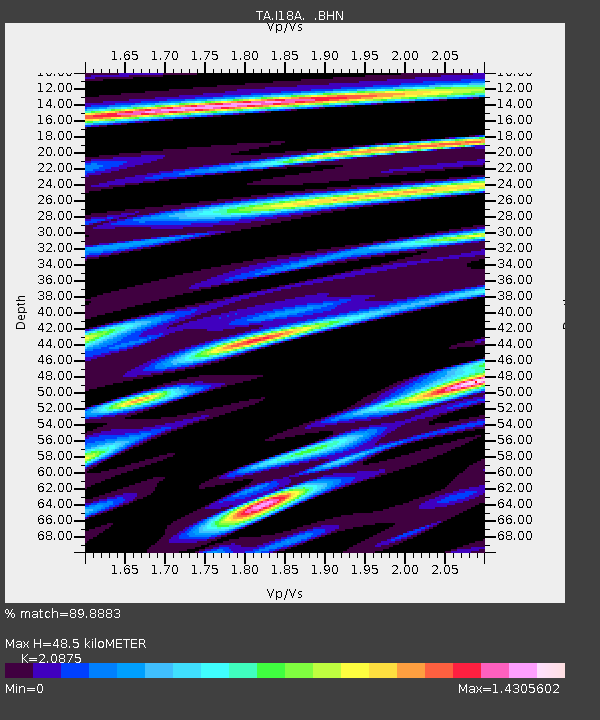
| Estimated Moho Depth: |
48.5 km |
| Estimated Crust Vp/Vs: |
2.09 |
| Assumed Crust Vp: |
6.161 km/s |
| Estimated Crust Vs: |
2.951 km/s |
| Estimated Crust Poisson's Ratio: |
0.35 |
|
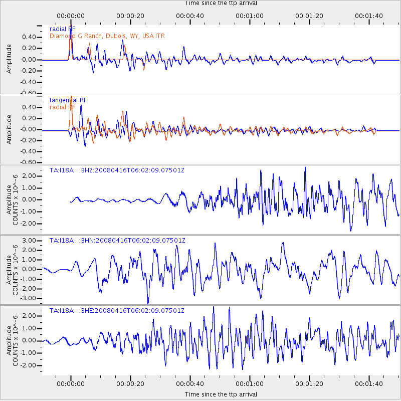
| Radial Match: |
89.8883 % |
| Radial Bump: |
400 |
| Transverse Match: |
85.12837 % |
| Transverse Bump: |
400 |
| SOD ConfigId: |
2504 |
| Insert Time: |
2010-03-06 22:40:37.799 +0000 |
| GWidth: |
2.5 |
| Max Bumps: |
400 |
| Tol: |
0.001 |
|
Signal To Noise
| Channel | StoN | STA | LTA |
| TA:I18A: :BHN:20080416T06:02:09.07501Z | 3.5814824 | 4.859219E-7 | 1.3567619E-7 |
| TA:I18A: :BHE:20080416T06:02:09.07501Z | 1.4872196 | 2.2404403E-7 | 1.5064623E-7 |
| TA:I18A: :BHZ:20080416T06:02:09.07501Z | 3.5891736 | 3.2705668E-7 | 9.112311E-8 |
| Arrivals |
| Ps | 9.0 SECOND |
| PpPs | 23 SECOND |
| PsPs/PpSs | 32 SECOND |


