You are here: Home > Network List > TA - USArray Transportable Network (new EarthScope stations) Stations List
> Station I18A Diamond G Ranch, Dubois, WY, USA > Earthquake Result Viewer
I18A Diamond G Ranch, Dubois, WY, USA - Earthquake Result Viewer

| Earthquake location: |
Solomon Islands |
| Earthquake latitude/longitude: |
-10.5/161.3 |
| Earthquake time(UTC): |
2008/06/03 (155) 16:20:50 GMT |
| Earthquake Depth: |
84 km |
| Earthquake Magnitude: |
6.2 MB, 6.2 MW, 6.2 MW |
| Earthquake Catalog/Contributor: |
WHDF/NEIC |
|
| Network: |
TA USArray Transportable Network (new EarthScope stations) |
| Station: |
I18A Diamond G Ranch, Dubois, WY, USA |
| Lat/Lon: |
43.70 N/109.82 W |
| Elevation: |
2322 m |
|
| Distance: |
96.4 deg |
| Az: |
46.858 deg |
| Baz: |
261.651 deg |
| Ray Param: |
0.040467747 |
| Estimated Moho Depth: |
64.0 km |
| Estimated Crust Vp/Vs: |
2.08 |
| Assumed Crust Vp: |
6.161 km/s |
| Estimated Crust Vs: |
2.969 km/s |
| Estimated Crust Poisson's Ratio: |
0.35 |
|
| Radial Match: |
88.31321 % |
| Radial Bump: |
400 |
| Transverse Match: |
85.00527 % |
| Transverse Bump: |
400 |
| SOD ConfigId: |
2504 |
| Insert Time: |
2010-03-06 22:40:39.309 +0000 |
| GWidth: |
2.5 |
| Max Bumps: |
400 |
| Tol: |
0.001 |
|
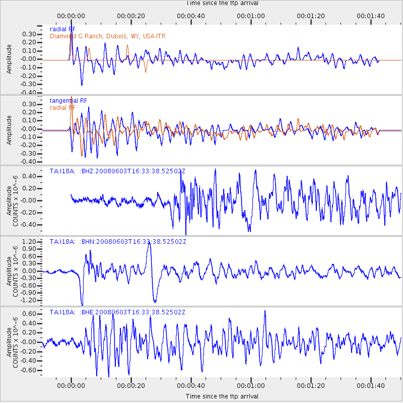
Signal To Noise
| Channel | StoN | STA | LTA |
| TA:I18A: :BHN:20080603T16:33:38.52502Z | 9.554642 | 5.197659E-7 | 5.4399308E-8 |
| TA:I18A: :BHE:20080603T16:33:38.52502Z | 1.6651064 | 9.7955656E-8 | 5.8828466E-8 |
| TA:I18A: :BHZ:20080603T16:33:38.52502Z | 3.4387019 | 1.4655441E-7 | 4.261911E-8 |
| Arrivals |
| Ps | 11 SECOND |
| PpPs | 31 SECOND |
| PsPs/PpSs | 43 SECOND |


