You are here: Home > Network List > TA - USArray Transportable Network (new EarthScope stations) Stations List
> Station I18A Diamond G Ranch, Dubois, WY, USA > Earthquake Result Viewer
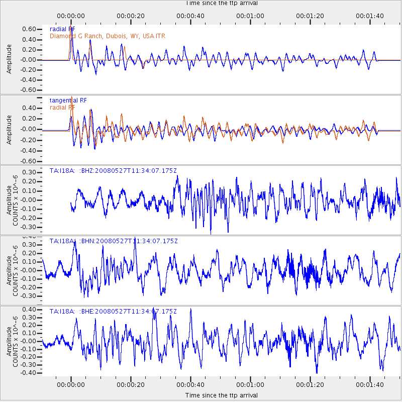
I18A Diamond G Ranch, Dubois, WY, USA - Earthquake Result Viewer
*The percent match for this event was below the threshold and hence no stack was calculated.
| Earthquake location: |
Near Coast Of Guatemala |
| Earthquake latitude/longitude: |
13.6/-91.0 |
| Earthquake time(UTC): |
2008/05/27 (148) 11:27:55 GMT |
| Earthquake Depth: |
26 km |
| Earthquake Magnitude: |
5.7 MW, 5.1 MS, 5.3 MB, 5.6 MW |
| Earthquake Catalog/Contributor: |
WHDF/NEIC |
|
| Network: |
TA USArray Transportable Network (new EarthScope stations) |
| Station: |
I18A Diamond G Ranch, Dubois, WY, USA |
| Lat/Lon: |
43.70 N/109.82 W |
| Elevation: |
2322 m |
|
| Distance: |
34.0 deg |
| Az: |
335.329 deg |
| Baz: |
145.975 deg |
| Ray Param: |
$rayparam |
*The percent match for this event was below the threshold and hence was not used in the summary stack. |
|
| Radial Match: |
71.40998 % |
| Radial Bump: |
400 |
| Transverse Match: |
61.985725 % |
| Transverse Bump: |
400 |
| SOD ConfigId: |
2504 |
| Insert Time: |
2010-03-06 22:40:53.379 +0000 |
| GWidth: |
2.5 |
| Max Bumps: |
400 |
| Tol: |
0.001 |
|
Signal To Noise
| Channel | StoN | STA | LTA |
| TA:I18A: :BHN:20080527T11:34:07.175Z | 2.3172584 | 1.7849025E-7 | 7.702648E-8 |
| TA:I18A: :BHE:20080527T11:34:07.175Z | 1.3910155 | 1.3062431E-7 | 9.390572E-8 |
| TA:I18A: :BHZ:20080527T11:34:07.175Z | 1.1063555 | 7.899005E-8 | 7.139663E-8 |
| Arrivals |
| Ps | |
| PpPs | |
| PsPs/PpSs | |


