You are here: Home > Network List > TA - USArray Transportable Network (new EarthScope stations) Stations List
> Station I18A Diamond G Ranch, Dubois, WY, USA > Earthquake Result Viewer
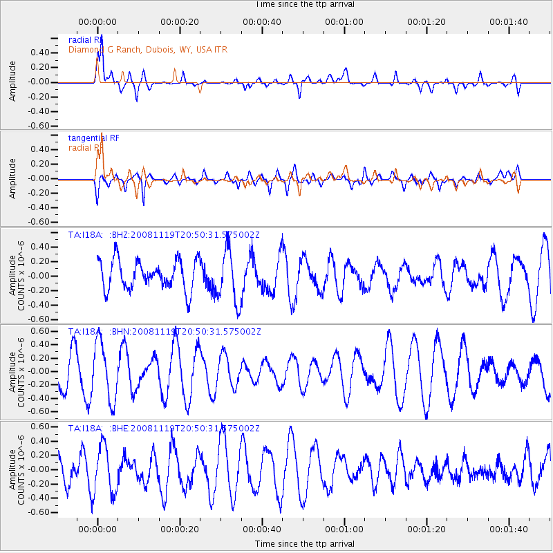
I18A Diamond G Ranch, Dubois, WY, USA - Earthquake Result Viewer
*The percent match for this event was below the threshold and hence no stack was calculated.
| Earthquake location: |
South Of Fiji Islands |
| Earthquake latitude/longitude: |
-22.2/-179.7 |
| Earthquake time(UTC): |
2008/11/19 (324) 20:38:58 GMT |
| Earthquake Depth: |
596 km |
| Earthquake Magnitude: |
5.8 MW, 5.2 MB, 5.8 MW |
| Earthquake Catalog/Contributor: |
WHDF/NEIC |
|
| Network: |
TA USArray Transportable Network (new EarthScope stations) |
| Station: |
I18A Diamond G Ranch, Dubois, WY, USA |
| Lat/Lon: |
43.70 N/109.82 W |
| Elevation: |
2322 m |
|
| Distance: |
91.6 deg |
| Az: |
42.949 deg |
| Baz: |
240.555 deg |
| Ray Param: |
$rayparam |
*The percent match for this event was below the threshold and hence was not used in the summary stack. |
|
| Radial Match: |
67.28335 % |
| Radial Bump: |
400 |
| Transverse Match: |
56.02476 % |
| Transverse Bump: |
400 |
| SOD ConfigId: |
2658 |
| Insert Time: |
2010-03-06 22:41:12.039 +0000 |
| GWidth: |
2.5 |
| Max Bumps: |
400 |
| Tol: |
0.001 |
|
Signal To Noise
| Channel | StoN | STA | LTA |
| TA:I18A: :BHN:20081119T20:50:31.575002Z | 2.311981 | 4.4108867E-7 | 1.9078387E-7 |
| TA:I18A: :BHE:20081119T20:50:31.575002Z | 1.5799681 | 3.322736E-7 | 2.1030401E-7 |
| TA:I18A: :BHZ:20081119T20:50:31.575002Z | 1.8305755 | 3.68543E-7 | 2.0132632E-7 |
| Arrivals |
| Ps | |
| PpPs | |
| PsPs/PpSs | |


