You are here: Home > Network List > TA - USArray Transportable Network (new EarthScope stations) Stations List
> Station L19K White Mountain, AK, USA > Earthquake Result Viewer
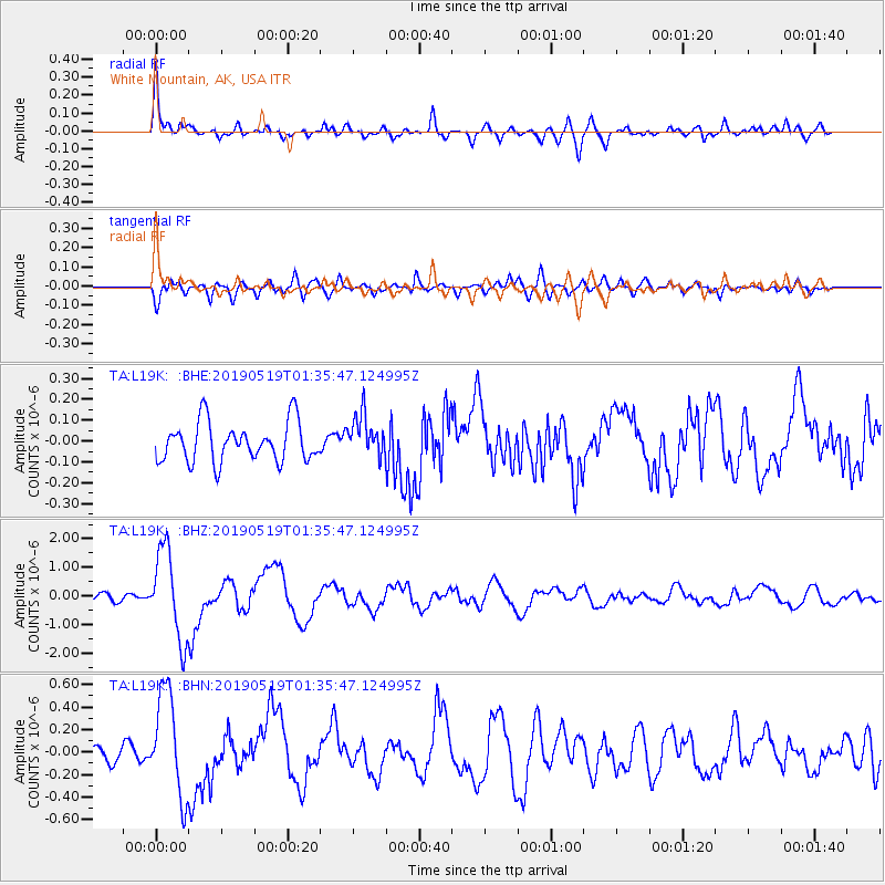
L19K White Mountain, AK, USA - Earthquake Result Viewer
| Earthquake location: |
Southeast Of Loyalty Islands |
| Earthquake latitude/longitude: |
-21.7/169.8 |
| Earthquake time(UTC): |
2019/05/19 (139) 01:23:29 GMT |
| Earthquake Depth: |
20 km |
| Earthquake Magnitude: |
6.3 mww |
| Earthquake Catalog/Contributor: |
NEIC PDE/us |
|
| Network: |
TA USArray Transportable Network (new EarthScope stations) |
| Station: |
L19K White Mountain, AK, USA |
| Lat/Lon: |
62.18 N/154.85 W |
| Elevation: |
650 m |
|
| Distance: |
88.2 deg |
| Az: |
15.754 deg |
| Baz: |
212.57 deg |
| Ray Param: |
0.04275926 |
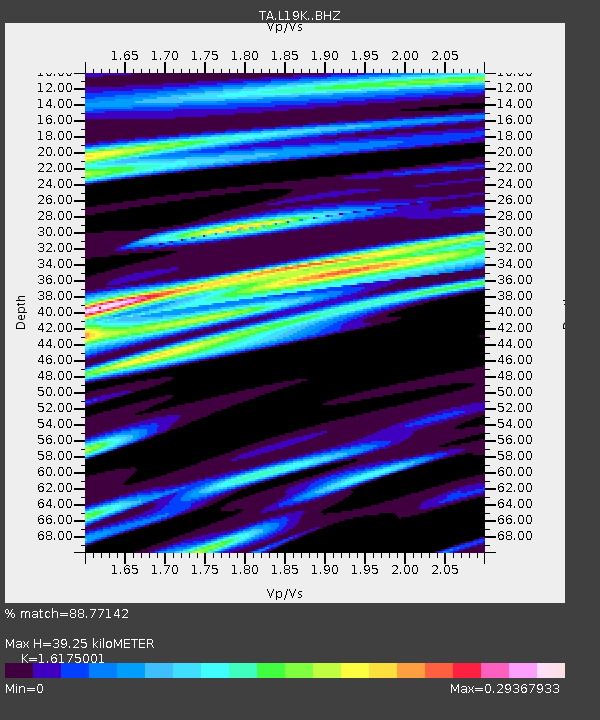
| Estimated Moho Depth: |
39.25 km |
| Estimated Crust Vp/Vs: |
1.62 |
| Assumed Crust Vp: |
6.438 km/s |
| Estimated Crust Vs: |
3.98 km/s |
| Estimated Crust Poisson's Ratio: |
0.19 |
|
| Radial Match: |
88.77142 % |
| Radial Bump: |
400 |
| Transverse Match: |
75.13809 % |
| Transverse Bump: |
400 |
| SOD ConfigId: |
18369291 |
| Insert Time: |
2019-06-02 01:29:15.904 +0000 |
| GWidth: |
2.5 |
| Max Bumps: |
400 |
| Tol: |
0.001 |
|
Signal To Noise
| Channel | StoN | STA | LTA |
| TA:L19K: :BHZ:20190519T01:35:47.124995Z | 14.6567135 | 1.5596543E-6 | 1.0641227E-7 |
| TA:L19K: :BHN:20190519T01:35:47.124995Z | 6.517314 | 4.6131686E-7 | 7.078328E-8 |
| TA:L19K: :BHE:20190519T01:35:47.124995Z | 1.0658823 | 1.0033455E-7 | 9.413286E-8 |
| Arrivals |
| Ps | 3.9 SECOND |
| PpPs | 16 SECOND |
| PsPs/PpSs | 19 SECOND |


