You are here: Home > Network List > TA - USArray Transportable Network (new EarthScope stations) Stations List
> Station M13K Dall Lake, AK, USA > Earthquake Result Viewer
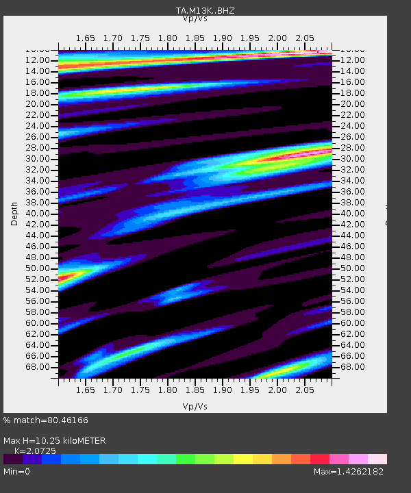
M13K Dall Lake, AK, USA - Earthquake Result Viewer
| Earthquake location: |
Southeast Of Loyalty Islands |
| Earthquake latitude/longitude: |
-21.7/169.8 |
| Earthquake time(UTC): |
2019/05/19 (139) 01:23:29 GMT |
| Earthquake Depth: |
20 km |
| Earthquake Magnitude: |
6.3 mww |
| Earthquake Catalog/Contributor: |
NEIC PDE/us |
|
| Network: |
TA USArray Transportable Network (new EarthScope stations) |
| Station: |
M13K Dall Lake, AK, USA |
| Lat/Lon: |
60.41 N/163.35 W |
| Elevation: |
9.0 m |
|
| Distance: |
84.7 deg |
| Az: |
13.007 deg |
| Baz: |
204.954 deg |
| Ray Param: |
0.045307145 |
| Estimated Moho Depth: |
10.25 km |
| Estimated Crust Vp/Vs: |
2.07 |
| Assumed Crust Vp: |
6.1 km/s |
| Estimated Crust Vs: |
2.943 km/s |
| Estimated Crust Poisson's Ratio: |
0.35 |
|
| Radial Match: |
80.46166 % |
| Radial Bump: |
400 |
| Transverse Match: |
59.295662 % |
| Transverse Bump: |
400 |
| SOD ConfigId: |
18369291 |
| Insert Time: |
2019-06-02 01:29:19.449 +0000 |
| GWidth: |
2.5 |
| Max Bumps: |
400 |
| Tol: |
0.001 |
|

Signal To Noise
| Channel | StoN | STA | LTA |
| TA:M13K: :BHZ:20190519T01:35:29.874995Z | 9.676732 | 2.6257514E-6 | 2.7134692E-7 |
| TA:M13K: :BHN:20190519T01:35:29.874995Z | 2.3577003 | 7.9864765E-7 | 3.387401E-7 |
| TA:M13K: :BHE:20190519T01:35:29.874995Z | 1.430918 | 5.751778E-7 | 4.0196423E-7 |
| Arrivals |
| Ps | 1.8 SECOND |
| PpPs | 5.1 SECOND |
| PsPs/PpSs | 6.9 SECOND |


