You are here: Home > Network List > TA - USArray Transportable Network (new EarthScope stations) Stations List
> Station O16K Kokwok River, Bristol Bay, AK, USA > Earthquake Result Viewer
O16K Kokwok River, Bristol Bay, AK, USA - Earthquake Result Viewer
| Earthquake location: |
Southeast Of Loyalty Islands |
| Earthquake latitude/longitude: |
-21.7/169.8 |
| Earthquake time(UTC): |
2019/05/19 (139) 01:23:29 GMT |
| Earthquake Depth: |
20 km |
| Earthquake Magnitude: |
6.3 mww |
| Earthquake Catalog/Contributor: |
NEIC PDE/us |
|
| Network: |
TA USArray Transportable Network (new EarthScope stations) |
| Station: |
O16K Kokwok River, Bristol Bay, AK, USA |
| Lat/Lon: |
59.59 N/158.09 W |
| Elevation: |
198 m |
|
| Distance: |
85.1 deg |
| Az: |
15.741 deg |
| Baz: |
209.743 deg |
| Ray Param: |
0.04495974 |
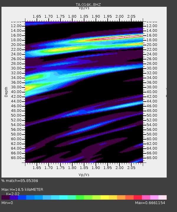
| Estimated Moho Depth: |
16.5 km |
| Estimated Crust Vp/Vs: |
2.02 |
| Assumed Crust Vp: |
6.24 km/s |
| Estimated Crust Vs: |
3.089 km/s |
| Estimated Crust Poisson's Ratio: |
0.34 |
|
| Radial Match: |
85.85386 % |
| Radial Bump: |
400 |
| Transverse Match: |
77.11495 % |
| Transverse Bump: |
400 |
| SOD ConfigId: |
18369291 |
| Insert Time: |
2019-06-02 01:29:34.451 +0000 |
| GWidth: |
2.5 |
| Max Bumps: |
400 |
| Tol: |
0.001 |
|

Signal To Noise
| Channel | StoN | STA | LTA |
| TA:O16K: :BHZ:20190519T01:35:32.299983Z | 16.241598 | 1.396823E-6 | 8.600281E-8 |
| TA:O16K: :BHN:20190519T01:35:32.299983Z | 4.8017554 | 4.1565931E-7 | 8.656403E-8 |
| TA:O16K: :BHE:20190519T01:35:32.299983Z | 3.5108147 | 2.0128496E-7 | 5.7332837E-8 |
| Arrivals |
| Ps | 2.8 SECOND |
| PpPs | 7.8 SECOND |
| PsPs/PpSs | 11 SECOND |


