You are here: Home > Network List > TA - USArray Transportable Network (new EarthScope stations) Stations List
> Station P18K Big Mountain, AK, USA > Earthquake Result Viewer
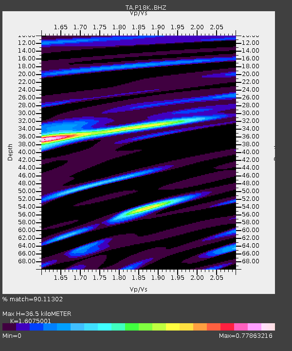
P18K Big Mountain, AK, USA - Earthquake Result Viewer
| Earthquake location: |
Southeast Of Loyalty Islands |
| Earthquake latitude/longitude: |
-21.7/169.8 |
| Earthquake time(UTC): |
2019/05/19 (139) 01:23:29 GMT |
| Earthquake Depth: |
20 km |
| Earthquake Magnitude: |
6.3 mww |
| Earthquake Catalog/Contributor: |
NEIC PDE/us |
|
| Network: |
TA USArray Transportable Network (new EarthScope stations) |
| Station: |
P18K Big Mountain, AK, USA |
| Lat/Lon: |
59.39 N/155.23 W |
| Elevation: |
680 m |
|
| Distance: |
85.7 deg |
| Az: |
17.102 deg |
| Baz: |
212.314 deg |
| Ray Param: |
0.044543687 |
| Estimated Moho Depth: |
36.5 km |
| Estimated Crust Vp/Vs: |
1.61 |
| Assumed Crust Vp: |
6.438 km/s |
| Estimated Crust Vs: |
4.005 km/s |
| Estimated Crust Poisson's Ratio: |
0.18 |
|
| Radial Match: |
90.11302 % |
| Radial Bump: |
400 |
| Transverse Match: |
84.82159 % |
| Transverse Bump: |
400 |
| SOD ConfigId: |
18369291 |
| Insert Time: |
2019-06-02 01:29:40.360 +0000 |
| GWidth: |
2.5 |
| Max Bumps: |
400 |
| Tol: |
0.001 |
|

Signal To Noise
| Channel | StoN | STA | LTA |
| TA:P18K: :BHZ:20190519T01:35:35.174983Z | 27.983938 | 2.239355E-6 | 8.0022865E-8 |
| TA:P18K: :BHN:20190519T01:35:35.174983Z | 4.829736 | 6.5018367E-7 | 1.3462095E-7 |
| TA:P18K: :BHE:20190519T01:35:35.174983Z | 5.371723 | 3.7088734E-7 | 6.904439E-8 |
| Arrivals |
| Ps | 3.5 SECOND |
| PpPs | 14 SECOND |
| PsPs/PpSs | 18 SECOND |


