You are here: Home > Network List > UU - University of Utah Regional Network Stations List
> Station FORU South Mineral Mountains, UT, USA > Earthquake Result Viewer
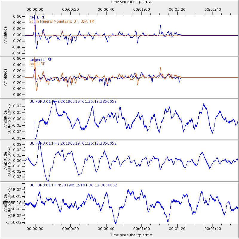
FORU South Mineral Mountains, UT, USA - Earthquake Result Viewer
*The percent match for this event was below the threshold and hence no stack was calculated.
| Earthquake location: |
Southeast Of Loyalty Islands |
| Earthquake latitude/longitude: |
-21.7/169.8 |
| Earthquake time(UTC): |
2019/05/19 (139) 01:23:29 GMT |
| Earthquake Depth: |
20 km |
| Earthquake Magnitude: |
6.3 mww |
| Earthquake Catalog/Contributor: |
NEIC PDE/us |
|
| Network: |
UU University of Utah Regional Network |
| Station: |
FORU South Mineral Mountains, UT, USA |
| Lat/Lon: |
38.46 N/112.86 W |
| Elevation: |
1840 m |
|
| Distance: |
93.9 deg |
| Az: |
50.15 deg |
| Baz: |
245.449 deg |
| Ray Param: |
$rayparam |
*The percent match for this event was below the threshold and hence was not used in the summary stack. |
|
| Radial Match: |
52.985985 % |
| Radial Bump: |
400 |
| Transverse Match: |
57.98254 % |
| Transverse Bump: |
400 |
| SOD ConfigId: |
18369291 |
| Insert Time: |
2019-06-02 01:30:26.556 +0000 |
| GWidth: |
2.5 |
| Max Bumps: |
400 |
| Tol: |
0.001 |
|
Signal To Noise
| Channel | StoN | STA | LTA |
| UU:FORU:01:HHZ:20190519T01:36:13.385005Z | 5.462341 | 1.7411733E-8 | 3.1875953E-9 |
| UU:FORU:01:HHN:20190519T01:36:13.385005Z | 1.0488678 | 3.9708627E-9 | 3.785856E-9 |
| UU:FORU:01:HHE:20190519T01:36:13.385005Z | 0.7546803 | 9.569479E-9 | 1.2680178E-8 |
| Arrivals |
| Ps | |
| PpPs | |
| PsPs/PpSs | |


