You are here: Home > Network List > TS - TERRAscope (Southern California Seismic Network) Stations List
> Station GLA Glamis, California, USA > Earthquake Result Viewer
GLA Glamis, California, USA - Earthquake Result Viewer
*The percent match for this event was below the threshold and hence no stack was calculated.
| Earthquake location: |
Southeast Of Loyalty Islands |
| Earthquake latitude/longitude: |
-22.2/171.5 |
| Earthquake time(UTC): |
1996/05/26 (147) 01:43:44 GMT |
| Earthquake Depth: |
108 km |
| Earthquake Magnitude: |
5.6 MB, 6.1 UNKNOWN, 6.1 MW |
| Earthquake Catalog/Contributor: |
WHDF/NEIC |
|
| Network: |
TS TERRAscope (Southern California Seismic Network) |
| Station: |
GLA Glamis, California, USA |
| Lat/Lon: |
33.05 N/114.83 W |
| Elevation: |
627 m |
|
| Distance: |
89.2 deg |
| Az: |
53.723 deg |
| Baz: |
242.829 deg |
| Ray Param: |
$rayparam |
*The percent match for this event was below the threshold and hence was not used in the summary stack. |
|
| Radial Match: |
60.07662 % |
| Radial Bump: |
400 |
| Transverse Match: |
55.44575 % |
| Transverse Bump: |
400 |
| SOD ConfigId: |
4480 |
| Insert Time: |
2010-02-26 14:13:38.413 +0000 |
| GWidth: |
2.5 |
| Max Bumps: |
400 |
| Tol: |
0.001 |
|
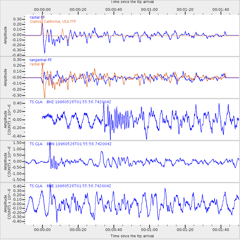
Signal To Noise
| Channel | StoN | STA | LTA |
| TS:GLA: :BHN:19960526T01:55:56.742004Z | 4.5327373 | 4.4331117E-7 | 9.780209E-8 |
| TS:GLA: :BHE:19960526T01:55:56.742004Z | 2.1675627 | 2.3561445E-7 | 1.0870017E-7 |
| TS:GLA: :BHZ:19960526T01:55:56.742004Z | 1.1383855 | 1.1532108E-7 | 1.01302305E-7 |
| Arrivals |
| Ps | |
| PpPs | |
| PsPs/PpSs | |


