You are here: Home > Network List > TA - USArray Transportable Network (new EarthScope stations) Stations List
> Station I18A Diamond G Ranch, Dubois, WY, USA > Earthquake Result Viewer
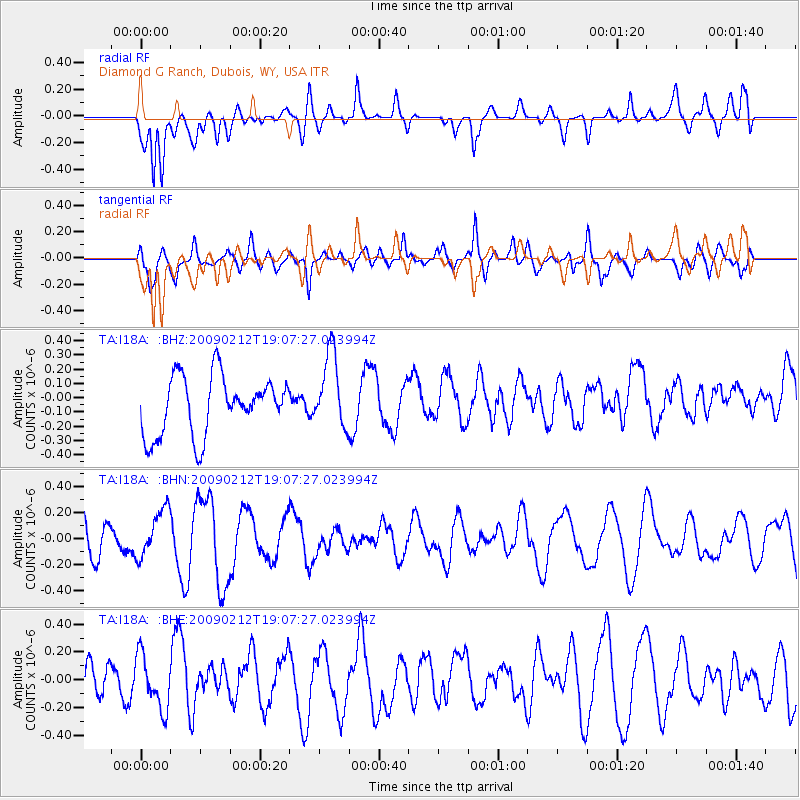
I18A Diamond G Ranch, Dubois, WY, USA - Earthquake Result Viewer
*The percent match for this event was below the threshold and hence no stack was calculated.
| Earthquake location: |
Kermadec Islands Region |
| Earthquake latitude/longitude: |
-31.2/-178.1 |
| Earthquake time(UTC): |
2009/02/12 (043) 18:54:28 GMT |
| Earthquake Depth: |
24 km |
| Earthquake Magnitude: |
5.6 MB, 5.6 MS, 5.9 MW, 5.8 MW |
| Earthquake Catalog/Contributor: |
WHDF/NEIC |
|
| Network: |
TA USArray Transportable Network (new EarthScope stations) |
| Station: |
I18A Diamond G Ranch, Dubois, WY, USA |
| Lat/Lon: |
43.70 N/109.82 W |
| Elevation: |
2322 m |
|
| Distance: |
97.2 deg |
| Az: |
42.781 deg |
| Baz: |
233.342 deg |
| Ray Param: |
$rayparam |
*The percent match for this event was below the threshold and hence was not used in the summary stack. |
|
| Radial Match: |
69.062416 % |
| Radial Bump: |
400 |
| Transverse Match: |
58.702255 % |
| Transverse Bump: |
400 |
| SOD ConfigId: |
2658 |
| Insert Time: |
2010-03-06 22:42:45.443 +0000 |
| GWidth: |
2.5 |
| Max Bumps: |
400 |
| Tol: |
0.001 |
|
Signal To Noise
| Channel | StoN | STA | LTA |
| TA:I18A: :BHN:20090212T19:07:27.023994Z | 0.60654783 | 1.8213474E-7 | 3.0028093E-7 |
| TA:I18A: :BHE:20090212T19:07:27.023994Z | 1.12746 | 1.9309489E-7 | 1.712654E-7 |
| TA:I18A: :BHZ:20090212T19:07:27.023994Z | 1.2975459 | 2.6433608E-7 | 2.0372002E-7 |
| Arrivals |
| Ps | |
| PpPs | |
| PsPs/PpSs | |


