You are here: Home > Network List > TS - TERRAscope (Southern California Seismic Network) Stations List
> Station GLA Glamis, California, USA > Earthquake Result Viewer
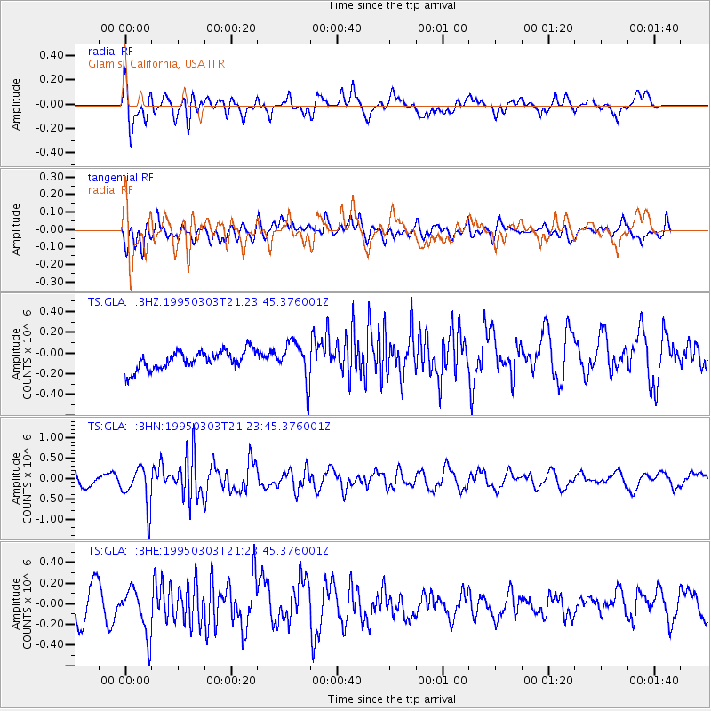
GLA Glamis, California, USA - Earthquake Result Viewer
*The percent match for this event was below the threshold and hence no stack was calculated.
| Earthquake location: |
Samoa Islands Region |
| Earthquake latitude/longitude: |
-14.6/-175.6 |
| Earthquake time(UTC): |
1995/03/03 (062) 21:12:37 GMT |
| Earthquake Depth: |
22 km |
| Earthquake Magnitude: |
5.6 MB, 5.7 MS, 5.9 UNKNOWN, 5.9 MW |
| Earthquake Catalog/Contributor: |
WHDF/NEIC |
|
| Network: |
TS TERRAscope (Southern California Seismic Network) |
| Station: |
GLA Glamis, California, USA |
| Lat/Lon: |
33.05 N/114.83 W |
| Elevation: |
627 m |
|
| Distance: |
74.9 deg |
| Az: |
49.406 deg |
| Baz: |
241.074 deg |
| Ray Param: |
$rayparam |
*The percent match for this event was below the threshold and hence was not used in the summary stack. |
|
| Radial Match: |
53.69123 % |
| Radial Bump: |
400 |
| Transverse Match: |
46.33459 % |
| Transverse Bump: |
400 |
| SOD ConfigId: |
4480 |
| Insert Time: |
2010-02-26 14:13:40.054 +0000 |
| GWidth: |
2.5 |
| Max Bumps: |
400 |
| Tol: |
0.001 |
|
Signal To Noise
| Channel | StoN | STA | LTA |
| TS:GLA: :BHN:19950303T21:23:45.376001Z | 2.7880566 | 4.964612E-7 | 1.7806713E-7 |
| TS:GLA: :BHE:19950303T21:23:45.376001Z | 1.5047141 | 2.2141592E-7 | 1.4714816E-7 |
| TS:GLA: :BHZ:19950303T21:23:45.376001Z | 2.1770887 | 1.9534454E-7 | 8.9727415E-8 |
| Arrivals |
| Ps | |
| PpPs | |
| PsPs/PpSs | |


