You are here: Home > Network List > TA - USArray Transportable Network (new EarthScope stations) Stations List
> Station G31M Satah River, YT, CAN > Earthquake Result Viewer
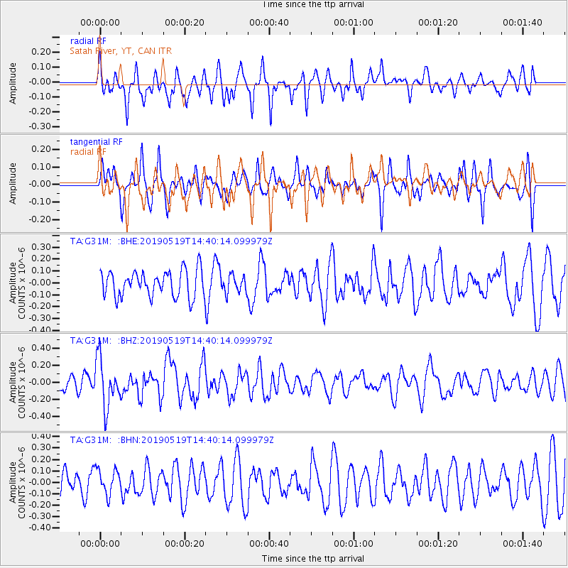
G31M Satah River, YT, CAN - Earthquake Result Viewer
*The percent match for this event was below the threshold and hence no stack was calculated.
| Earthquake location: |
Southeast Of Loyalty Islands |
| Earthquake latitude/longitude: |
-21.7/169.6 |
| Earthquake time(UTC): |
2019/05/19 (139) 14:27:10 GMT |
| Earthquake Depth: |
10 km |
| Earthquake Magnitude: |
5.9 Mww |
| Earthquake Catalog/Contributor: |
NEIC PDE/us |
|
| Network: |
TA USArray Transportable Network (new EarthScope stations) |
| Station: |
G31M Satah River, YT, CAN |
| Lat/Lon: |
66.92 N/134.27 W |
| Elevation: |
61 m |
|
| Distance: |
97.7 deg |
| Az: |
19.295 deg |
| Baz: |
231.204 deg |
| Ray Param: |
$rayparam |
*The percent match for this event was below the threshold and hence was not used in the summary stack. |
|
| Radial Match: |
56.286324 % |
| Radial Bump: |
400 |
| Transverse Match: |
51.74789 % |
| Transverse Bump: |
359 |
| SOD ConfigId: |
18369291 |
| Insert Time: |
2019-06-02 14:31:26.583 +0000 |
| GWidth: |
2.5 |
| Max Bumps: |
400 |
| Tol: |
0.001 |
|
Signal To Noise
| Channel | StoN | STA | LTA |
| TA:G31M: :BHZ:20190519T14:40:14.099979Z | 2.9504137 | 2.854929E-7 | 9.676368E-8 |
| TA:G31M: :BHN:20190519T14:40:14.099979Z | 1.2208601 | 1.0917949E-7 | 8.942833E-8 |
| TA:G31M: :BHE:20190519T14:40:14.099979Z | 0.6700988 | 7.3466154E-8 | 1.09634804E-7 |
| Arrivals |
| Ps | |
| PpPs | |
| PsPs/PpSs | |


