You are here: Home > Network List > ET - CERI Southern Appalachian seismic Network Stations List
> Station FPAL Fort Payne,AL > Earthquake Result Viewer
FPAL Fort Payne,AL - Earthquake Result Viewer
| Earthquake location: |
Chile-Argentina Border Region |
| Earthquake latitude/longitude: |
-35.1/-71.0 |
| Earthquake time(UTC): |
2016/11/04 (309) 16:20:43 GMT |
| Earthquake Depth: |
91 km |
| Earthquake Magnitude: |
6.4 MWP, 6.4 MWW |
| Earthquake Catalog/Contributor: |
NEIC PDE/NEIC COMCAT |
|
| Network: |
ET CERI Southern Appalachian seismic Network |
| Station: |
FPAL Fort Payne,AL |
| Lat/Lon: |
34.54 N/85.61 W |
| Elevation: |
556 m |
|
| Distance: |
70.6 deg |
| Az: |
347.244 deg |
| Baz: |
167.332 deg |
| Ray Param: |
0.054642387 |
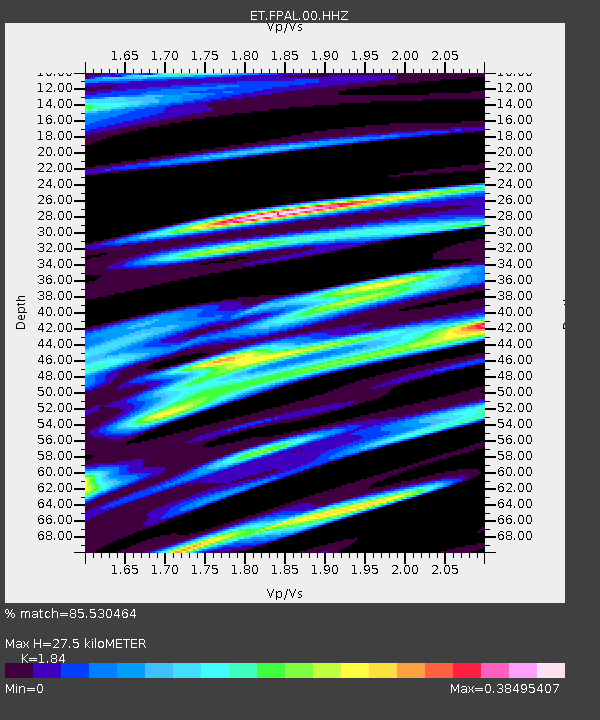
| Estimated Moho Depth: |
27.5 km |
| Estimated Crust Vp/Vs: |
1.84 |
| Assumed Crust Vp: |
6.35 km/s |
| Estimated Crust Vs: |
3.451 km/s |
| Estimated Crust Poisson's Ratio: |
0.29 |
|
| Radial Match: |
85.530464 % |
| Radial Bump: |
371 |
| Transverse Match: |
45.58717 % |
| Transverse Bump: |
400 |
| SOD ConfigId: |
1815711 |
| Insert Time: |
2016-11-18 16:22:30.619 +0000 |
| GWidth: |
2.5 |
| Max Bumps: |
400 |
| Tol: |
0.001 |
|

Signal To Noise
| Channel | StoN | STA | LTA |
| ET:FPAL:00:HHZ:20161104T16:31:18.695005Z | 13.091164 | 2.9061953E-6 | 2.2199671E-7 |
| ET:FPAL:00:HHN:20161104T16:31:18.695005Z | 4.7068458 | 1.1039418E-6 | 2.3453961E-7 |
| ET:FPAL:00:HHE:20161104T16:31:18.695005Z | 0.70170707 | 2.8323282E-7 | 4.03634E-7 |
| Arrivals |
| Ps | 3.8 SECOND |
| PpPs | 12 SECOND |
| PsPs/PpSs | 16 SECOND |


