You are here: Home > Network List > TA - USArray Transportable Network (new EarthScope stations) Stations List
> Station S06C San Francisco Camp Mather, Mather, CA, USA > Earthquake Result Viewer
S06C San Francisco Camp Mather, Mather, CA, USA - Earthquake Result Viewer
| Earthquake location: |
Fiji Islands Region |
| Earthquake latitude/longitude: |
-15.3/-178.6 |
| Earthquake time(UTC): |
2005/12/13 (347) 03:16:06 GMT |
| Earthquake Depth: |
10 km |
| Earthquake Magnitude: |
6.1 MB, 6.8 MS, 6.7 MW, 6.7 MW |
| Earthquake Catalog/Contributor: |
WHDF/NEIC |
|
| Network: |
TA USArray Transportable Network (new EarthScope stations) |
| Station: |
S06C San Francisco Camp Mather, Mather, CA, USA |
| Lat/Lon: |
37.88 N/119.85 W |
| Elevation: |
1377 m |
|
| Distance: |
76.3 deg |
| Az: |
44.108 deg |
| Baz: |
238.101 deg |
| Ray Param: |
0.051074516 |
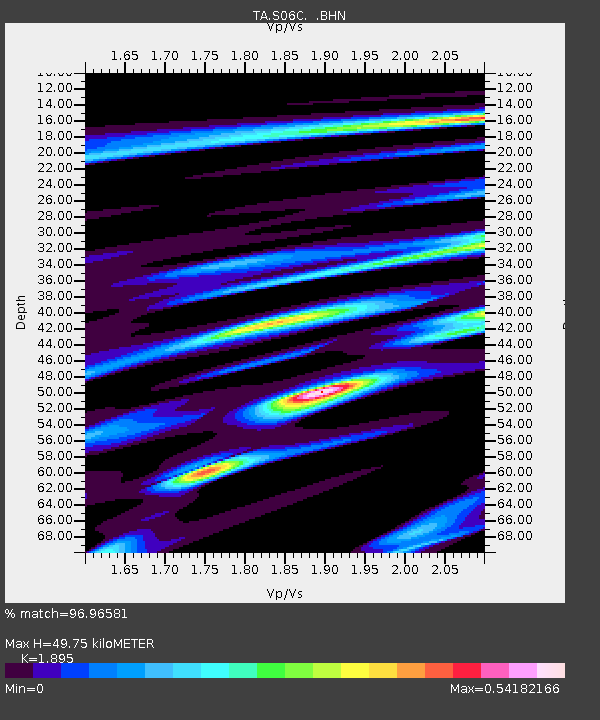
| Estimated Moho Depth: |
49.75 km |
| Estimated Crust Vp/Vs: |
1.89 |
| Assumed Crust Vp: |
6.291 km/s |
| Estimated Crust Vs: |
3.32 km/s |
| Estimated Crust Poisson's Ratio: |
0.31 |
|
| Radial Match: |
96.96581 % |
| Radial Bump: |
254 |
| Transverse Match: |
85.1767 % |
| Transverse Bump: |
400 |
| SOD ConfigId: |
2564 |
| Insert Time: |
2010-03-06 22:43:02.340 +0000 |
| GWidth: |
2.5 |
| Max Bumps: |
400 |
| Tol: |
0.001 |
|
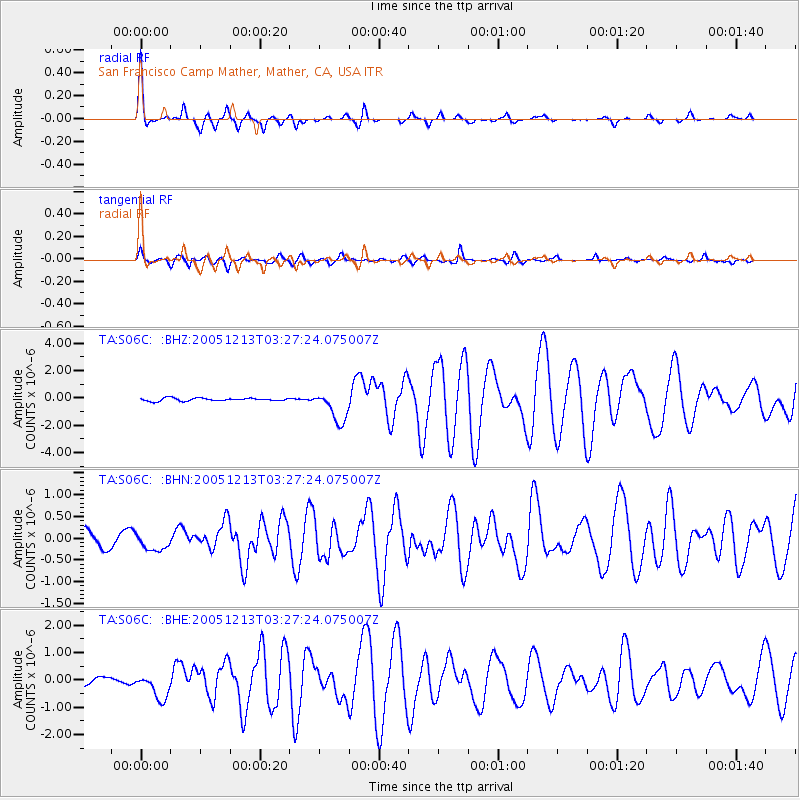
Signal To Noise
| Channel | StoN | STA | LTA |
| TA:S06C: :BHN:20051213T03:27:24.075007Z | 1.0527399 | 1.9188325E-7 | 1.8227033E-7 |
| TA:S06C: :BHE:20051213T03:27:24.075007Z | 4.0389276 | 4.764096E-7 | 1.17954485E-7 |
| TA:S06C: :BHZ:20051213T03:27:24.075007Z | 10.931047 | 1.1407349E-6 | 1.04357326E-7 |
| Arrivals |
| Ps | 7.3 SECOND |
| PpPs | 22 SECOND |
| PsPs/PpSs | 30 SECOND |


