You are here: Home > Network List > TA - USArray Transportable Network (new EarthScope stations) Stations List
> Station S06C San Francisco Camp Mather, Mather, CA, USA > Earthquake Result Viewer
S06C San Francisco Camp Mather, Mather, CA, USA - Earthquake Result Viewer
| Earthquake location: |
Chile-Bolivia Border Region |
| Earthquake latitude/longitude: |
-22.3/-67.9 |
| Earthquake time(UTC): |
2005/11/17 (321) 19:26:56 GMT |
| Earthquake Depth: |
163 km |
| Earthquake Magnitude: |
6.0 MB, 6.9 MW, 6.8 MW |
| Earthquake Catalog/Contributor: |
WHDF/NEIC |
|
| Network: |
TA USArray Transportable Network (new EarthScope stations) |
| Station: |
S06C San Francisco Camp Mather, Mather, CA, USA |
| Lat/Lon: |
37.88 N/119.85 W |
| Elevation: |
1377 m |
|
| Distance: |
77.3 deg |
| Az: |
320.287 deg |
| Baz: |
131.607 deg |
| Ray Param: |
0.050039325 |
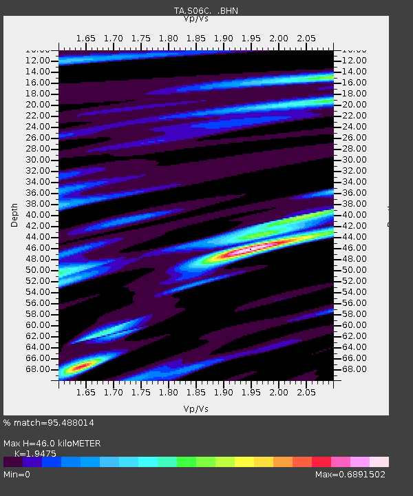
| Estimated Moho Depth: |
46.0 km |
| Estimated Crust Vp/Vs: |
1.95 |
| Assumed Crust Vp: |
6.291 km/s |
| Estimated Crust Vs: |
3.23 km/s |
| Estimated Crust Poisson's Ratio: |
0.32 |
|
| Radial Match: |
95.488014 % |
| Radial Bump: |
331 |
| Transverse Match: |
94.16669 % |
| Transverse Bump: |
400 |
| SOD ConfigId: |
2422 |
| Insert Time: |
2010-03-06 22:43:03.958 +0000 |
| GWidth: |
2.5 |
| Max Bumps: |
400 |
| Tol: |
0.001 |
|

Signal To Noise
| Channel | StoN | STA | LTA |
| TA:S06C: :BHN:20051117T19:38:01.648994Z | 18.180458 | 1.7893428E-6 | 9.842122E-8 |
| TA:S06C: :BHE:20051117T19:38:01.648994Z | 9.816085 | 9.024162E-7 | 9.193239E-8 |
| TA:S06C: :BHZ:20051117T19:38:01.648994Z | 52.144146 | 5.22547E-6 | 1.0021201E-7 |
| Arrivals |
| Ps | 7.1 SECOND |
| PpPs | 21 SECOND |
| PsPs/PpSs | 28 SECOND |


