You are here: Home > Network List > TA - USArray Transportable Network (new EarthScope stations) Stations List
> Station R31K City Hall, Gustavus, AK, USA > Earthquake Result Viewer
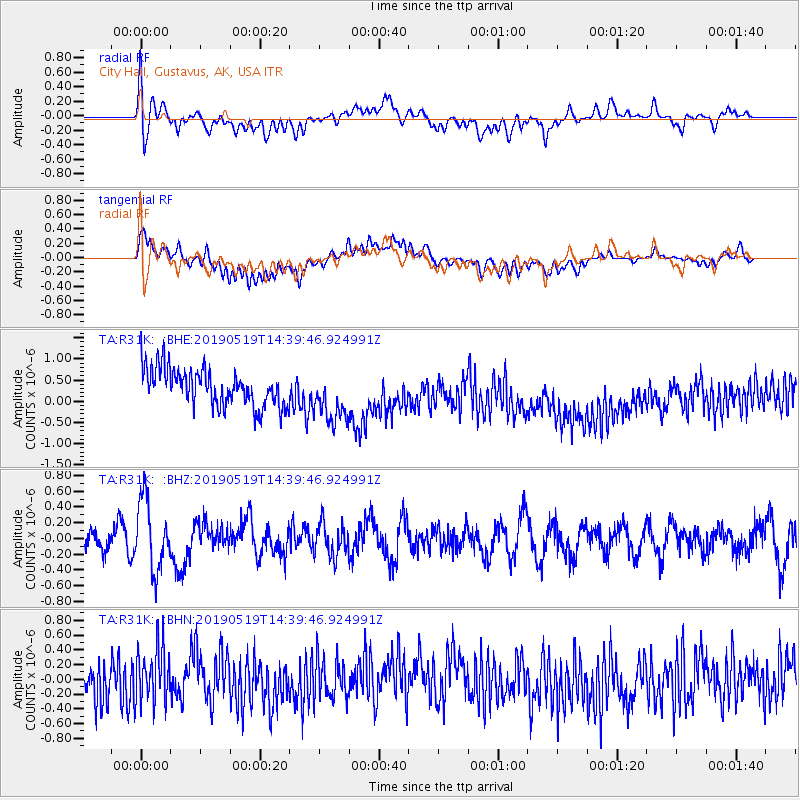
R31K City Hall, Gustavus, AK, USA - Earthquake Result Viewer
*The percent match for this event was below the threshold and hence no stack was calculated.
| Earthquake location: |
Southeast Of Loyalty Islands |
| Earthquake latitude/longitude: |
-21.7/169.6 |
| Earthquake time(UTC): |
2019/05/19 (139) 14:27:10 GMT |
| Earthquake Depth: |
10 km |
| Earthquake Magnitude: |
5.9 Mww |
| Earthquake Catalog/Contributor: |
NEIC PDE/us |
|
| Network: |
TA USArray Transportable Network (new EarthScope stations) |
| Station: |
R31K City Hall, Gustavus, AK, USA |
| Lat/Lon: |
58.41 N/135.74 W |
| Elevation: |
15 m |
|
| Distance: |
91.7 deg |
| Az: |
25.451 deg |
| Baz: |
229.389 deg |
| Ray Param: |
$rayparam |
*The percent match for this event was below the threshold and hence was not used in the summary stack. |
|
| Radial Match: |
43.750504 % |
| Radial Bump: |
400 |
| Transverse Match: |
34.318523 % |
| Transverse Bump: |
400 |
| SOD ConfigId: |
18369291 |
| Insert Time: |
2019-06-02 14:32:16.170 +0000 |
| GWidth: |
2.5 |
| Max Bumps: |
400 |
| Tol: |
0.001 |
|
Signal To Noise
| Channel | StoN | STA | LTA |
| TA:R31K: :BHZ:20190519T14:39:46.924991Z | 2.531178 | 4.413863E-7 | 1.743798E-7 |
| TA:R31K: :BHN:20190519T14:39:46.924991Z | 1.2771866 | 3.8037314E-7 | 2.9782112E-7 |
| TA:R31K: :BHE:20190519T14:39:46.924991Z | 1.4410362 | 6.182247E-7 | 4.2901402E-7 |
| Arrivals |
| Ps | |
| PpPs | |
| PsPs/PpSs | |


