You are here: Home > Network List > TA - USArray Transportable Network (new EarthScope stations) Stations List
> Station S06C San Francisco Camp Mather, Mather, CA, USA > Earthquake Result Viewer
S06C San Francisco Camp Mather, Mather, CA, USA - Earthquake Result Viewer
| Earthquake location: |
Santa Cruz Islands |
| Earthquake latitude/longitude: |
-11.4/166.3 |
| Earthquake time(UTC): |
2007/08/12 (224) 12:05:19 GMT |
| Earthquake Depth: |
42 km |
| Earthquake Magnitude: |
5.8 MB, 5.7 MS, 6.0 MW, 6.0 MW |
| Earthquake Catalog/Contributor: |
WHDF/NEIC |
|
| Network: |
TA USArray Transportable Network (new EarthScope stations) |
| Station: |
S06C San Francisco Camp Mather, Mather, CA, USA |
| Lat/Lon: |
37.88 N/119.85 W |
| Elevation: |
1377 m |
|
| Distance: |
84.5 deg |
| Az: |
49.787 deg |
| Baz: |
251.151 deg |
| Ray Param: |
0.045362763 |
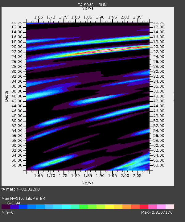
| Estimated Moho Depth: |
21.0 km |
| Estimated Crust Vp/Vs: |
1.94 |
| Assumed Crust Vp: |
6.291 km/s |
| Estimated Crust Vs: |
3.243 km/s |
| Estimated Crust Poisson's Ratio: |
0.32 |
|
| Radial Match: |
80.32298 % |
| Radial Bump: |
400 |
| Transverse Match: |
69.86576 % |
| Transverse Bump: |
400 |
| SOD ConfigId: |
2564 |
| Insert Time: |
2010-03-06 22:43:18.765 +0000 |
| GWidth: |
2.5 |
| Max Bumps: |
400 |
| Tol: |
0.001 |
|

Signal To Noise
| Channel | StoN | STA | LTA |
| TA:S06C: :BHN:20070812T12:17:17.225Z | 1.1359009 | 6.604423E-8 | 5.81426E-8 |
| TA:S06C: :BHE:20070812T12:17:17.225Z | 4.3793964 | 2.1819342E-7 | 4.9822717E-8 |
| TA:S06C: :BHZ:20070812T12:17:17.225Z | 12.102614 | 5.56038E-7 | 4.5943626E-8 |
| Arrivals |
| Ps | 3.2 SECOND |
| PpPs | 9.6 SECOND |
| PsPs/PpSs | 13 SECOND |


