You are here: Home > Network List > TA - USArray Transportable Network (new EarthScope stations) Stations List
> Station S06C San Francisco Camp Mather, Mather, CA, USA > Earthquake Result Viewer
S06C San Francisco Camp Mather, Mather, CA, USA - Earthquake Result Viewer
| Earthquake location: |
Vanuatu Islands |
| Earthquake latitude/longitude: |
-15.6/167.7 |
| Earthquake time(UTC): |
2007/08/01 (213) 17:08:51 GMT |
| Earthquake Depth: |
120 km |
| Earthquake Magnitude: |
6.2 MB, 7.2 MW, 7.2 MW |
| Earthquake Catalog/Contributor: |
WHDF/NEIC |
|
| Network: |
TA USArray Transportable Network (new EarthScope stations) |
| Station: |
S06C San Francisco Camp Mather, Mather, CA, USA |
| Lat/Lon: |
37.88 N/119.85 W |
| Elevation: |
1377 m |
|
| Distance: |
86.2 deg |
| Az: |
49.13 deg |
| Baz: |
247.062 deg |
| Ray Param: |
0.043963823 |
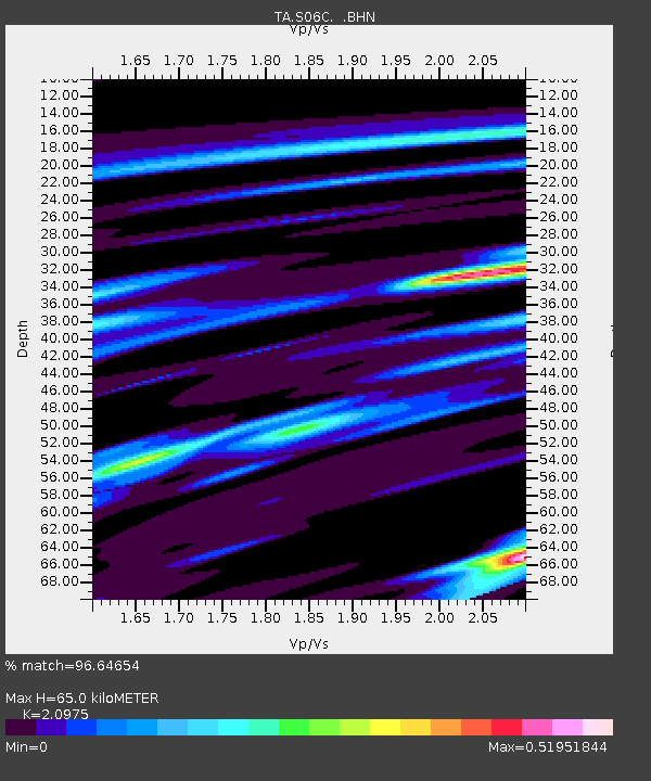
| Estimated Moho Depth: |
65.0 km |
| Estimated Crust Vp/Vs: |
2.10 |
| Assumed Crust Vp: |
6.291 km/s |
| Estimated Crust Vs: |
2.999 km/s |
| Estimated Crust Poisson's Ratio: |
0.35 |
|
| Radial Match: |
96.64654 % |
| Radial Bump: |
304 |
| Transverse Match: |
86.576965 % |
| Transverse Bump: |
400 |
| SOD ConfigId: |
2564 |
| Insert Time: |
2010-03-06 22:43:21.001 +0000 |
| GWidth: |
2.5 |
| Max Bumps: |
400 |
| Tol: |
0.001 |
|

Signal To Noise
| Channel | StoN | STA | LTA |
| TA:S06C: :BHN:20070801T17:20:48.150Z | 1.6735297 | 1.2710298E-7 | 7.5949046E-8 |
| TA:S06C: :BHE:20070801T17:20:48.150Z | 4.2449303 | 2.8345445E-7 | 6.6774824E-8 |
| TA:S06C: :BHZ:20070801T17:20:48.150Z | 6.3204885 | 8.861545E-7 | 1.4020348E-7 |
| Arrivals |
| Ps | 12 SECOND |
| PpPs | 31 SECOND |
| PsPs/PpSs | 43 SECOND |


