You are here: Home > Network List > TA - USArray Transportable Network (new EarthScope stations) Stations List
> Station S06C San Francisco Camp Mather, Mather, CA, USA > Earthquake Result Viewer
S06C San Francisco Camp Mather, Mather, CA, USA - Earthquake Result Viewer
| Earthquake location: |
Jujuy Province, Argentina |
| Earthquake latitude/longitude: |
-22.2/-65.8 |
| Earthquake time(UTC): |
2007/07/21 (202) 15:34:52 GMT |
| Earthquake Depth: |
290 km |
| Earthquake Magnitude: |
5.8 MB, 6.4 MW, 6.3 MW |
| Earthquake Catalog/Contributor: |
WHDF/NEIC |
|
| Network: |
TA USArray Transportable Network (new EarthScope stations) |
| Station: |
S06C San Francisco Camp Mather, Mather, CA, USA |
| Lat/Lon: |
37.88 N/119.85 W |
| Elevation: |
1377 m |
|
| Distance: |
78.4 deg |
| Az: |
319.148 deg |
| Baz: |
129.971 deg |
| Ray Param: |
0.048898548 |
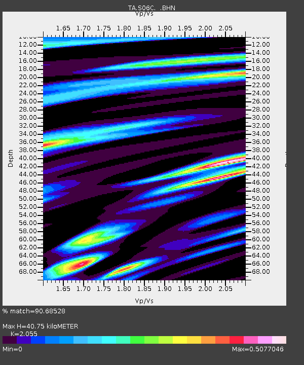
| Estimated Moho Depth: |
40.75 km |
| Estimated Crust Vp/Vs: |
2.06 |
| Assumed Crust Vp: |
6.291 km/s |
| Estimated Crust Vs: |
3.061 km/s |
| Estimated Crust Poisson's Ratio: |
0.34 |
|
| Radial Match: |
90.68528 % |
| Radial Bump: |
327 |
| Transverse Match: |
83.382225 % |
| Transverse Bump: |
400 |
| SOD ConfigId: |
2564 |
| Insert Time: |
2010-03-06 22:43:23.682 +0000 |
| GWidth: |
2.5 |
| Max Bumps: |
400 |
| Tol: |
0.001 |
|
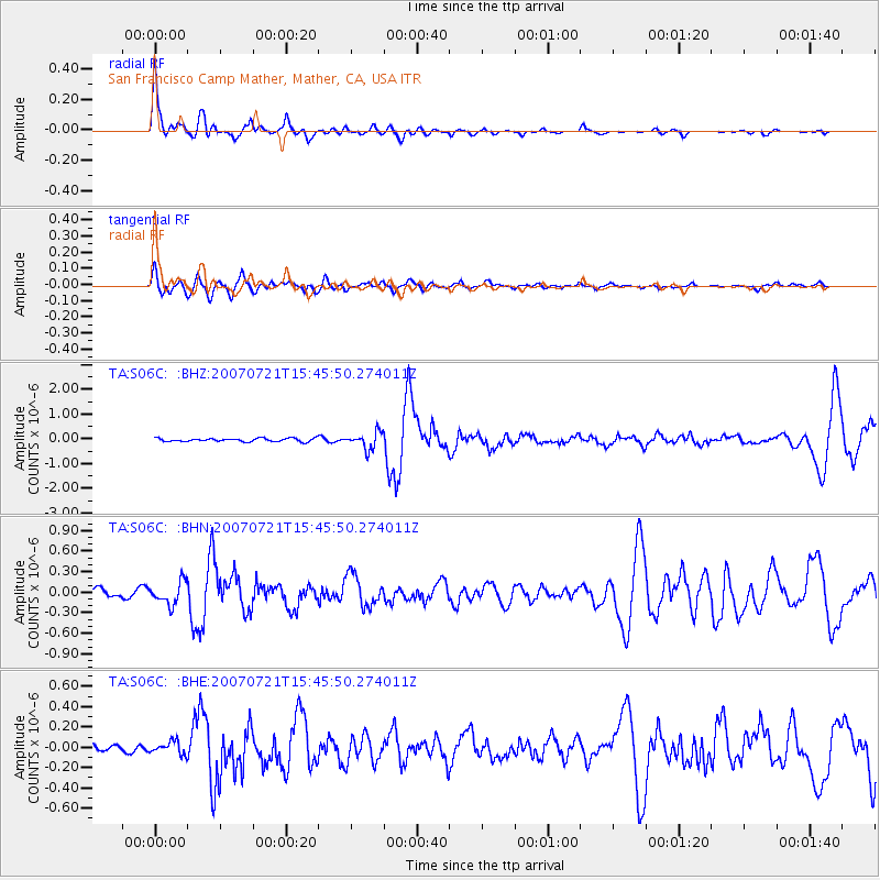
Signal To Noise
| Channel | StoN | STA | LTA |
| TA:S06C: :BHN:20070721T15:45:50.274011Z | 3.3525367 | 1.6033978E-7 | 4.7826404E-8 |
| TA:S06C: :BHE:20070721T15:45:50.274011Z | 1.4023855 | 6.204599E-8 | 4.424318E-8 |
| TA:S06C: :BHZ:20070721T15:45:50.274011Z | 5.0161905 | 3.3578064E-7 | 6.693937E-8 |
| Arrivals |
| Ps | 7.0 SECOND |
| PpPs | 19 SECOND |
| PsPs/PpSs | 26 SECOND |


