You are here: Home > Network List > TA - USArray Transportable Network (new EarthScope stations) Stations List
> Station S06C San Francisco Camp Mather, Mather, CA, USA > Earthquake Result Viewer
S06C San Francisco Camp Mather, Mather, CA, USA - Earthquake Result Viewer

| Earthquake location: |
Mariana Islands Region |
| Earthquake latitude/longitude: |
20.8/146.2 |
| Earthquake time(UTC): |
2006/02/14 (045) 15:27:23 GMT |
| Earthquake Depth: |
40 km |
| Earthquake Magnitude: |
6.2 MB, 6.1 MS, 6.3 MW, 6.2 MW |
| Earthquake Catalog/Contributor: |
WHDF/NEIC |
|
| Network: |
TA USArray Transportable Network (new EarthScope stations) |
| Station: |
S06C San Francisco Camp Mather, Mather, CA, USA |
| Lat/Lon: |
37.88 N/119.85 W |
| Elevation: |
1377 m |
|
| Distance: |
80.5 deg |
| Az: |
53.16 deg |
| Baz: |
288.884 deg |
| Ray Param: |
0.048163168 |
| Estimated Moho Depth: |
41.0 km |
| Estimated Crust Vp/Vs: |
1.98 |
| Assumed Crust Vp: |
6.291 km/s |
| Estimated Crust Vs: |
3.181 km/s |
| Estimated Crust Poisson's Ratio: |
0.33 |
|
| Radial Match: |
83.52364 % |
| Radial Bump: |
306 |
| Transverse Match: |
74.08361 % |
| Transverse Bump: |
345 |
| SOD ConfigId: |
2422 |
| Insert Time: |
2010-03-06 22:43:59.910 +0000 |
| GWidth: |
2.5 |
| Max Bumps: |
400 |
| Tol: |
0.001 |
|
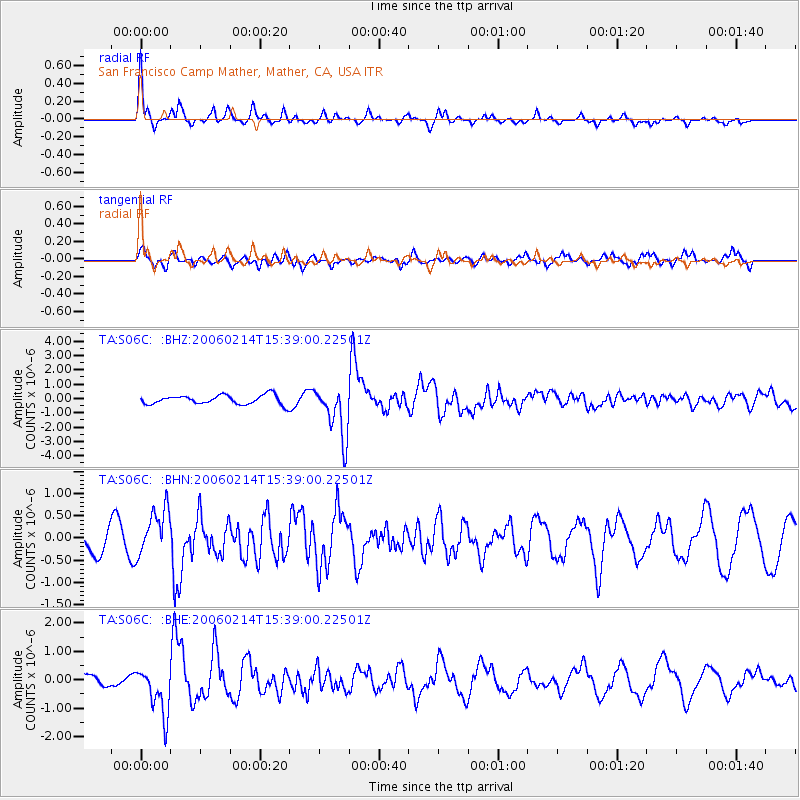
Signal To Noise
| Channel | StoN | STA | LTA |
| TA:S06C: :BHN:20060214T15:39:00.22501Z | 2.5334322 | 5.298805E-7 | 2.0915519E-7 |
| TA:S06C: :BHE:20060214T15:39:00.22501Z | 2.7855015 | 8.278456E-7 | 2.9719806E-7 |
| TA:S06C: :BHZ:20060214T15:39:00.22501Z | 5.639972 | 1.8153123E-6 | 3.2186546E-7 |
| Arrivals |
| Ps | 6.5 SECOND |
| PpPs | 19 SECOND |
| PsPs/PpSs | 25 SECOND |


