You are here: Home > Network List > TA - USArray Transportable Network (new EarthScope stations) Stations List
> Station S06C San Francisco Camp Mather, Mather, CA, USA > Earthquake Result Viewer
S06C San Francisco Camp Mather, Mather, CA, USA - Earthquake Result Viewer
| Earthquake location: |
Sea Of Japan |
| Earthquake latitude/longitude: |
41.4/135.7 |
| Earthquake time(UTC): |
2006/09/16 (259) 02:22:50 GMT |
| Earthquake Depth: |
367 km |
| Earthquake Magnitude: |
5.4 MB, 5.9 MW, 5.9 MW |
| Earthquake Catalog/Contributor: |
WHDF/NEIC |
|
| Network: |
TA USArray Transportable Network (new EarthScope stations) |
| Station: |
S06C San Francisco Camp Mather, Mather, CA, USA |
| Lat/Lon: |
37.88 N/119.85 W |
| Elevation: |
1377 m |
|
| Distance: |
75.3 deg |
| Az: |
52.39 deg |
| Baz: |
311.098 deg |
| Ray Param: |
0.05070455 |
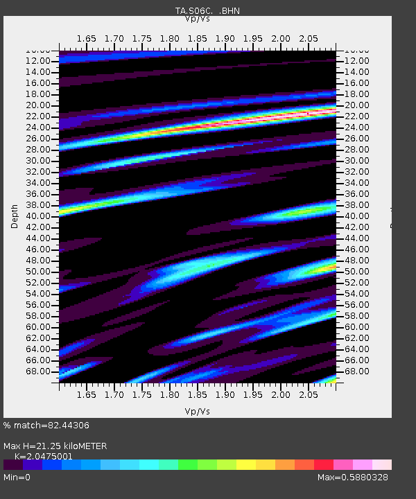
| Estimated Moho Depth: |
21.25 km |
| Estimated Crust Vp/Vs: |
2.05 |
| Assumed Crust Vp: |
6.291 km/s |
| Estimated Crust Vs: |
3.073 km/s |
| Estimated Crust Poisson's Ratio: |
0.34 |
|
| Radial Match: |
82.44306 % |
| Radial Bump: |
289 |
| Transverse Match: |
73.75315 % |
| Transverse Bump: |
400 |
| SOD ConfigId: |
2564 |
| Insert Time: |
2010-03-06 22:44:10.193 +0000 |
| GWidth: |
2.5 |
| Max Bumps: |
400 |
| Tol: |
0.001 |
|
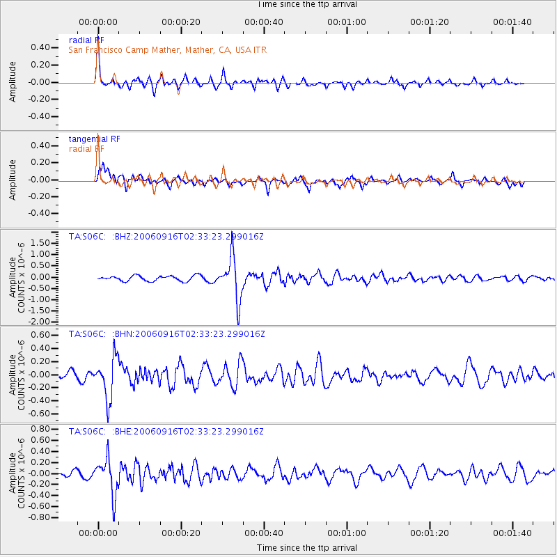
Signal To Noise
| Channel | StoN | STA | LTA |
| TA:S06C: :BHN:20060916T02:33:23.299016Z | 6.9788632 | 3.2951507E-7 | 4.7216155E-8 |
| TA:S06C: :BHE:20060916T02:33:23.299016Z | 4.6005383 | 3.4098713E-7 | 7.411896E-8 |
| TA:S06C: :BHZ:20060916T02:33:23.299016Z | 8.296539 | 9.850667E-7 | 1.1873224E-7 |
| Arrivals |
| Ps | 3.6 SECOND |
| PpPs | 10 SECOND |
| PsPs/PpSs | 14 SECOND |


