You are here: Home > Network List > TA - USArray Transportable Network (new EarthScope stations) Stations List
> Station S06C San Francisco Camp Mather, Mather, CA, USA > Earthquake Result Viewer
S06C San Francisco Camp Mather, Mather, CA, USA - Earthquake Result Viewer

| Earthquake location: |
La Rioja Province, Argentina |
| Earthquake latitude/longitude: |
-28.9/-68.9 |
| Earthquake time(UTC): |
2006/09/12 (255) 13:30:55 GMT |
| Earthquake Depth: |
114 km |
| Earthquake Magnitude: |
5.8 MB, 6.0 MW, 5.9 MW |
| Earthquake Catalog/Contributor: |
WHDF/NEIC |
|
| Network: |
TA USArray Transportable Network (new EarthScope stations) |
| Station: |
S06C San Francisco Camp Mather, Mather, CA, USA |
| Lat/Lon: |
37.88 N/119.85 W |
| Elevation: |
1377 m |
|
| Distance: |
81.8 deg |
| Az: |
321.622 deg |
| Baz: |
136.553 deg |
| Ray Param: |
0.04706996 |
| Estimated Moho Depth: |
41.25 km |
| Estimated Crust Vp/Vs: |
2.06 |
| Assumed Crust Vp: |
6.291 km/s |
| Estimated Crust Vs: |
3.054 km/s |
| Estimated Crust Poisson's Ratio: |
0.35 |
|
| Radial Match: |
80.921326 % |
| Radial Bump: |
400 |
| Transverse Match: |
68.71361 % |
| Transverse Bump: |
400 |
| SOD ConfigId: |
2564 |
| Insert Time: |
2010-03-06 22:44:11.763 +0000 |
| GWidth: |
2.5 |
| Max Bumps: |
400 |
| Tol: |
0.001 |
|
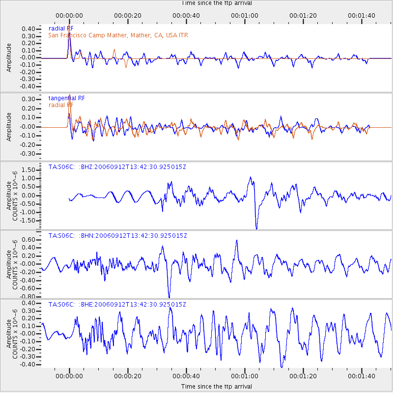
Signal To Noise
| Channel | StoN | STA | LTA |
| TA:S06C: :BHN:20060912T13:42:30.925015Z | 0.7446937 | 7.68455E-8 | 1.0319075E-7 |
| TA:S06C: :BHE:20060912T13:42:30.925015Z | 0.89930934 | 1.0134961E-7 | 1.1269716E-7 |
| TA:S06C: :BHZ:20060912T13:42:30.925015Z | 2.5141747 | 4.4250584E-7 | 1.760044E-7 |
| Arrivals |
| Ps | 7.1 SECOND |
| PpPs | 20 SECOND |
| PsPs/PpSs | 27 SECOND |


