You are here: Home > Network List > TA - USArray Transportable Network (new EarthScope stations) Stations List
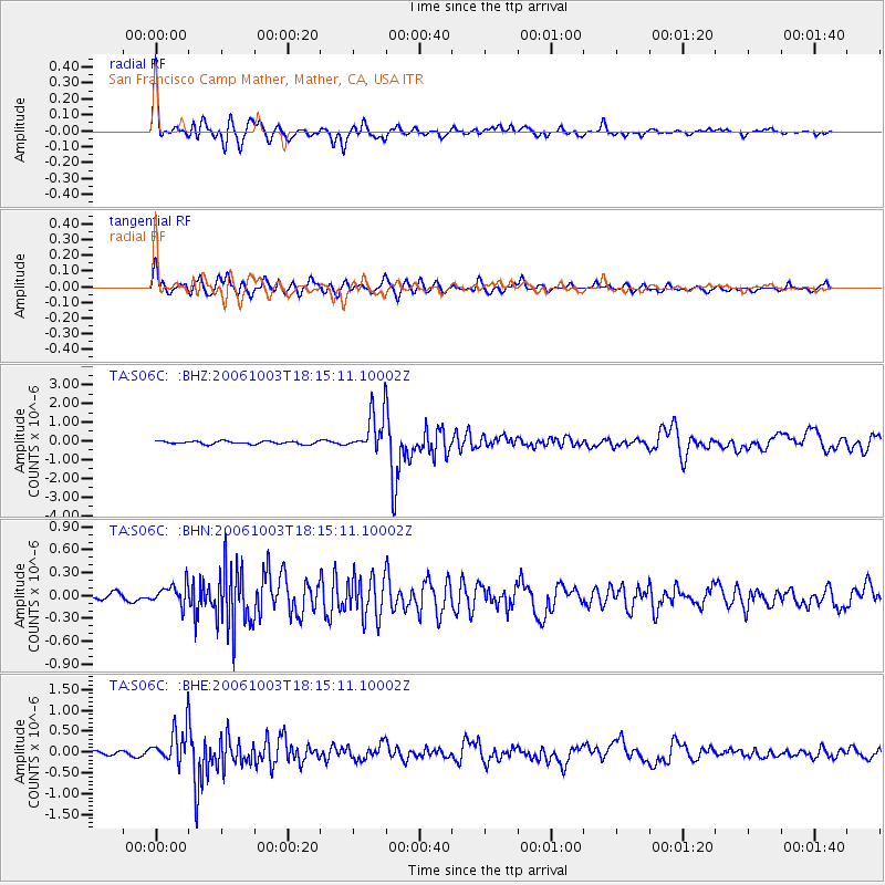
> Station S06C San Francisco Camp Mather, Mather, CA, USA > Earthquake Result Viewer
S06C San Francisco Camp Mather, Mather, CA, USA - Earthquake Result Viewer
| Earthquake location: |
Vanuatu Islands |
| Earthquake latitude/longitude: |
-18.9/169.0 |
| Earthquake time(UTC): |
2006/10/03 (276) 18:03:14 GMT |
| Earthquake Depth: |
171 km |
| Earthquake Magnitude: |
5.9 MB, 6.3 MW, 6.3 MW |
| Earthquake Catalog/Contributor: |
WHDF/NEIC |
|
| Network: |
TA USArray Transportable Network (new EarthScope stations) |
| Station: |
S06C San Francisco Camp Mather, Mather, CA, USA |
| Lat/Lon: |
37.88 N/119.85 W |
| Elevation: |
1377 m |
|
| Distance: |
87.4 deg |
| Az: |
48.556 deg |
| Baz: |
243.774 deg |
| Ray Param: |
0.04296977 |
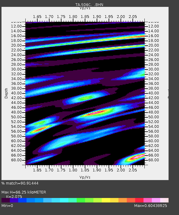
| Estimated Moho Depth: |
66.25 km |
| Estimated Crust Vp/Vs: |
2.08 |
| Assumed Crust Vp: |
6.291 km/s |
| Estimated Crust Vs: |
3.032 km/s |
| Estimated Crust Poisson's Ratio: |
0.35 |
|
| Radial Match: |
90.91444 % |
| Radial Bump: |
400 |
| Transverse Match: |
81.22526 % |
| Transverse Bump: |
400 |
| SOD ConfigId: |
2665 |
| Insert Time: |
2010-03-06 22:44:18.261 +0000 |
| GWidth: |
2.5 |
| Max Bumps: |
400 |
| Tol: |
0.001 |
|
Signal To Noise
| Channel | StoN | STA | LTA |
| TA:S06C: :BHN:20061003T18:15:11.10002Z | 2.061688 | 1.4357734E-7 | 6.964068E-8 |
| TA:S06C: :BHE:20061003T18:15:11.10002Z | 9.018294 | 4.1799143E-7 | 4.6349278E-8 |
| TA:S06C: :BHZ:20061003T18:15:11.10002Z | 13.9552555 | 1.0771533E-6 | 7.7186215E-8 |
| Arrivals |
| Ps | 12 SECOND |
| PpPs | 32 SECOND |
| PsPs/PpSs | 43 SECOND |


