You are here: Home > Network List > GS - US Geological Survey Networks Stations List
> Station OK035 E0210 Rd and N2420 Rd, Alva, Oklahoma, USA > Earthquake Result Viewer
OK035 E0210 Rd and N2420 Rd, Alva, Oklahoma, USA - Earthquake Result Viewer
| Earthquake location: |
Chile-Argentina Border Region |
| Earthquake latitude/longitude: |
-35.1/-71.0 |
| Earthquake time(UTC): |
2016/11/04 (309) 16:20:43 GMT |
| Earthquake Depth: |
91 km |
| Earthquake Magnitude: |
6.4 MWP, 6.4 MWW |
| Earthquake Catalog/Contributor: |
NEIC PDE/NEIC COMCAT |
|
| Network: |
GS US Geological Survey Networks |
| Station: |
OK035 E0210 Rd and N2420 Rd, Alva, Oklahoma, USA |
| Lat/Lon: |
36.71 N/98.71 W |
| Elevation: |
485 m |
|
| Distance: |
76.0 deg |
| Az: |
337.342 deg |
| Baz: |
156.856 deg |
| Ray Param: |
0.051109195 |
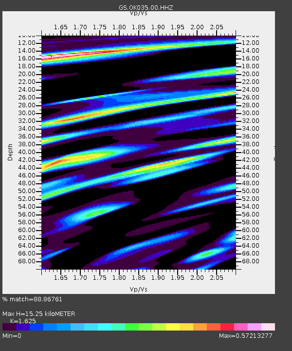
| Estimated Moho Depth: |
15.25 km |
| Estimated Crust Vp/Vs: |
1.62 |
| Assumed Crust Vp: |
6.426 km/s |
| Estimated Crust Vs: |
3.955 km/s |
| Estimated Crust Poisson's Ratio: |
0.20 |
|
| Radial Match: |
88.86761 % |
| Radial Bump: |
400 |
| Transverse Match: |
71.85627 % |
| Transverse Bump: |
400 |
| SOD ConfigId: |
1815711 |
| Insert Time: |
2016-11-18 16:23:54.464 +0000 |
| GWidth: |
2.5 |
| Max Bumps: |
400 |
| Tol: |
0.001 |
|

Signal To Noise
| Channel | StoN | STA | LTA |
| GS:OK035:00:HHZ:20161104T16:31:49.999998Z | 7.819345 | 2.943609E-6 | 3.764521E-7 |
| GS:OK035:00:HH1:20161104T16:31:49.999998Z | 2.5963323 | 1.305958E-6 | 5.030011E-7 |
| GS:OK035:00:HH2:20161104T16:31:49.999998Z | 1.2330061 | 8.023373E-7 | 6.507164E-7 |
| Arrivals |
| Ps | 1.5 SECOND |
| PpPs | 6.0 SECOND |
| PsPs/PpSs | 7.6 SECOND |


