You are here: Home > Network List > MM - Myanmar National Seismic Network Stations List
> Station HKA Haka, Chin, Myanmar > Earthquake Result Viewer
HKA Haka, Chin, Myanmar - Earthquake Result Viewer
| Earthquake location: |
Southeast Of Loyalty Islands |
| Earthquake latitude/longitude: |
-21.6/169.5 |
| Earthquake time(UTC): |
2019/05/19 (139) 14:56:50 GMT |
| Earthquake Depth: |
20 km |
| Earthquake Magnitude: |
6.3 mww |
| Earthquake Catalog/Contributor: |
NEIC PDE/us |
|
| Network: |
MM Myanmar National Seismic Network |
| Station: |
HKA Haka, Chin, Myanmar |
| Lat/Lon: |
22.64 N/93.60 E |
| Elevation: |
1733 m |
|
| Distance: |
86.0 deg |
| Az: |
296.094 deg |
| Baz: |
115.228 deg |
| Ray Param: |
0.044344988 |
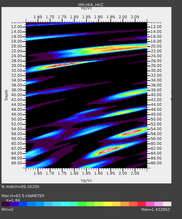
| Estimated Moho Depth: |
62.5 km |
| Estimated Crust Vp/Vs: |
1.94 |
| Assumed Crust Vp: |
6.552 km/s |
| Estimated Crust Vs: |
3.378 km/s |
| Estimated Crust Poisson's Ratio: |
0.32 |
|
| Radial Match: |
85.34208 % |
| Radial Bump: |
400 |
| Transverse Match: |
72.95913 % |
| Transverse Bump: |
400 |
| SOD ConfigId: |
18369291 |
| Insert Time: |
2019-06-02 15:00:00.799 +0000 |
| GWidth: |
2.5 |
| Max Bumps: |
400 |
| Tol: |
0.001 |
|

Signal To Noise
| Channel | StoN | STA | LTA |
| MM:HKA: :HHZ:20190519T15:08:58.118002Z | 8.723116 | 7.8697354E-7 | 9.021702E-8 |
| MM:HKA: :HHN:20190519T15:08:58.118002Z | 0.6844103 | 1.701731E-7 | 2.4864195E-7 |
| MM:HKA: :HHE:20190519T15:08:58.118002Z | 1.8984444 | 2.3978427E-7 | 1.2630565E-7 |
| Arrivals |
| Ps | 9.2 SECOND |
| PpPs | 27 SECOND |
| PsPs/PpSs | 37 SECOND |


