You are here: Home > Network List > TA - USArray Transportable Network (new EarthScope stations) Stations List
> Station B18K Kokolik River, AK, USA > Earthquake Result Viewer
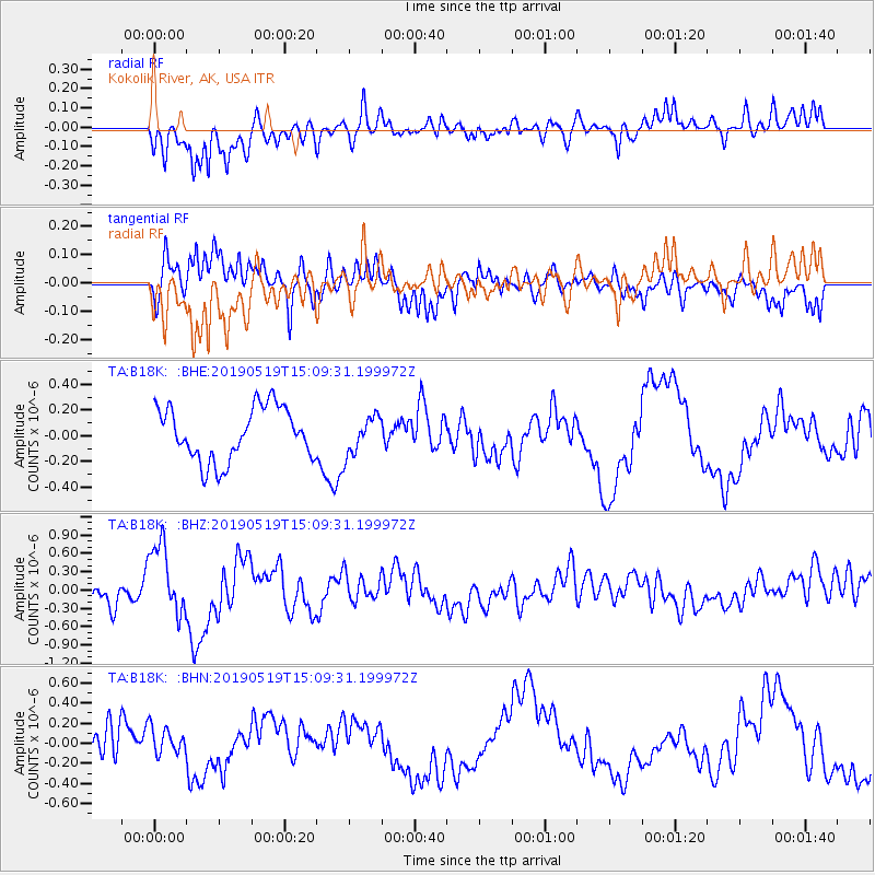
B18K Kokolik River, AK, USA - Earthquake Result Viewer
*The percent match for this event was below the threshold and hence no stack was calculated.
| Earthquake location: |
Southeast Of Loyalty Islands |
| Earthquake latitude/longitude: |
-21.6/169.5 |
| Earthquake time(UTC): |
2019/05/19 (139) 14:56:50 GMT |
| Earthquake Depth: |
20 km |
| Earthquake Magnitude: |
6.3 mww |
| Earthquake Catalog/Contributor: |
NEIC PDE/us |
|
| Network: |
TA USArray Transportable Network (new EarthScope stations) |
| Station: |
B18K Kokolik River, AK, USA |
| Lat/Lon: |
69.36 N/161.80 W |
| Elevation: |
222 m |
|
| Distance: |
93.0 deg |
| Az: |
9.825 deg |
| Baz: |
206.611 deg |
| Ray Param: |
$rayparam |
*The percent match for this event was below the threshold and hence was not used in the summary stack. |
|
| Radial Match: |
68.022934 % |
| Radial Bump: |
400 |
| Transverse Match: |
62.722157 % |
| Transverse Bump: |
400 |
| SOD ConfigId: |
18369291 |
| Insert Time: |
2019-06-02 15:00:46.612 +0000 |
| GWidth: |
2.5 |
| Max Bumps: |
400 |
| Tol: |
0.001 |
|
Signal To Noise
| Channel | StoN | STA | LTA |
| TA:B18K: :BHZ:20190519T15:09:31.199972Z | 3.2576387 | 5.857292E-7 | 1.7980176E-7 |
| TA:B18K: :BHN:20190519T15:09:31.199972Z | 1.114894 | 1.3607614E-7 | 1.2205298E-7 |
| TA:B18K: :BHE:20190519T15:09:31.199972Z | 0.72060525 | 1.4761251E-7 | 2.0484516E-7 |
| Arrivals |
| Ps | |
| PpPs | |
| PsPs/PpSs | |


