You are here: Home > Network List > TA - USArray Transportable Network (new EarthScope stations) Stations List
> Station E20K Nigu River, AK, USA > Earthquake Result Viewer
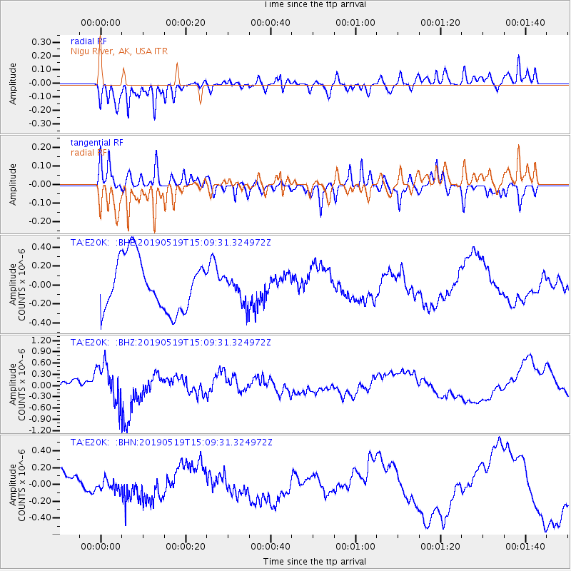
E20K Nigu River, AK, USA - Earthquake Result Viewer
*The percent match for this event was below the threshold and hence no stack was calculated.
| Earthquake location: |
Southeast Of Loyalty Islands |
| Earthquake latitude/longitude: |
-21.6/169.5 |
| Earthquake time(UTC): |
2019/05/19 (139) 14:56:50 GMT |
| Earthquake Depth: |
20 km |
| Earthquake Magnitude: |
6.3 mww |
| Earthquake Catalog/Contributor: |
NEIC PDE/us |
|
| Network: |
TA USArray Transportable Network (new EarthScope stations) |
| Station: |
E20K Nigu River, AK, USA |
| Lat/Lon: |
68.26 N/156.19 W |
| Elevation: |
866 m |
|
| Distance: |
93.1 deg |
| Az: |
12.151 deg |
| Baz: |
211.717 deg |
| Ray Param: |
$rayparam |
*The percent match for this event was below the threshold and hence was not used in the summary stack. |
|
| Radial Match: |
74.366486 % |
| Radial Bump: |
400 |
| Transverse Match: |
59.41925 % |
| Transverse Bump: |
400 |
| SOD ConfigId: |
18369291 |
| Insert Time: |
2019-06-02 15:00:59.282 +0000 |
| GWidth: |
2.5 |
| Max Bumps: |
400 |
| Tol: |
0.001 |
|
Signal To Noise
| Channel | StoN | STA | LTA |
| TA:E20K: :BHZ:20190519T15:09:31.324972Z | 3.546862 | 5.0911103E-7 | 1.4353844E-7 |
| TA:E20K: :BHN:20190519T15:09:31.324972Z | 0.43551022 | 6.8485186E-8 | 1.5725276E-7 |
| TA:E20K: :BHE:20190519T15:09:31.324972Z | 0.5226666 | 1.414515E-7 | 2.706343E-7 |
| Arrivals |
| Ps | |
| PpPs | |
| PsPs/PpSs | |


