You are here: Home > Network List > TA - USArray Transportable Network (new EarthScope stations) Stations List
> Station J26L Joseph Creek, AK, USA > Earthquake Result Viewer
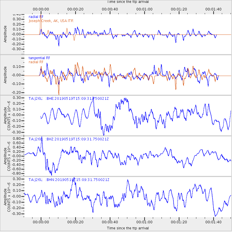
J26L Joseph Creek, AK, USA - Earthquake Result Viewer
*The percent match for this event was below the threshold and hence no stack was calculated.
| Earthquake location: |
Southeast Of Loyalty Islands |
| Earthquake latitude/longitude: |
-21.6/169.5 |
| Earthquake time(UTC): |
2019/05/19 (139) 14:56:50 GMT |
| Earthquake Depth: |
20 km |
| Earthquake Magnitude: |
6.3 mww |
| Earthquake Catalog/Contributor: |
NEIC PDE/us |
|
| Network: |
TA USArray Transportable Network (new EarthScope stations) |
| Station: |
J26L Joseph Creek, AK, USA |
| Lat/Lon: |
64.50 N/143.56 W |
| Elevation: |
1144 m |
|
| Distance: |
93.2 deg |
| Az: |
18.474 deg |
| Baz: |
222.941 deg |
| Ray Param: |
$rayparam |
*The percent match for this event was below the threshold and hence was not used in the summary stack. |
|
| Radial Match: |
62.468792 % |
| Radial Bump: |
348 |
| Transverse Match: |
71.46013 % |
| Transverse Bump: |
400 |
| SOD ConfigId: |
18369291 |
| Insert Time: |
2019-06-02 15:01:32.231 +0000 |
| GWidth: |
2.5 |
| Max Bumps: |
400 |
| Tol: |
0.001 |
|
Signal To Noise
| Channel | StoN | STA | LTA |
| TA:J26L: :BHZ:20190519T15:09:31.750021Z | 3.748896 | 4.4798207E-7 | 1.1949707E-7 |
| TA:J26L: :BHN:20190519T15:09:31.750021Z | 0.96818143 | 6.331793E-8 | 6.539882E-8 |
| TA:J26L: :BHE:20190519T15:09:31.750021Z | 1.8744346 | 1.5625432E-7 | 8.3360774E-8 |
| Arrivals |
| Ps | |
| PpPs | |
| PsPs/PpSs | |


