You are here: Home > Network List > TA - USArray Transportable Network (new EarthScope stations) Stations List
> Station M11K Mekoryuk, AK, USA > Earthquake Result Viewer
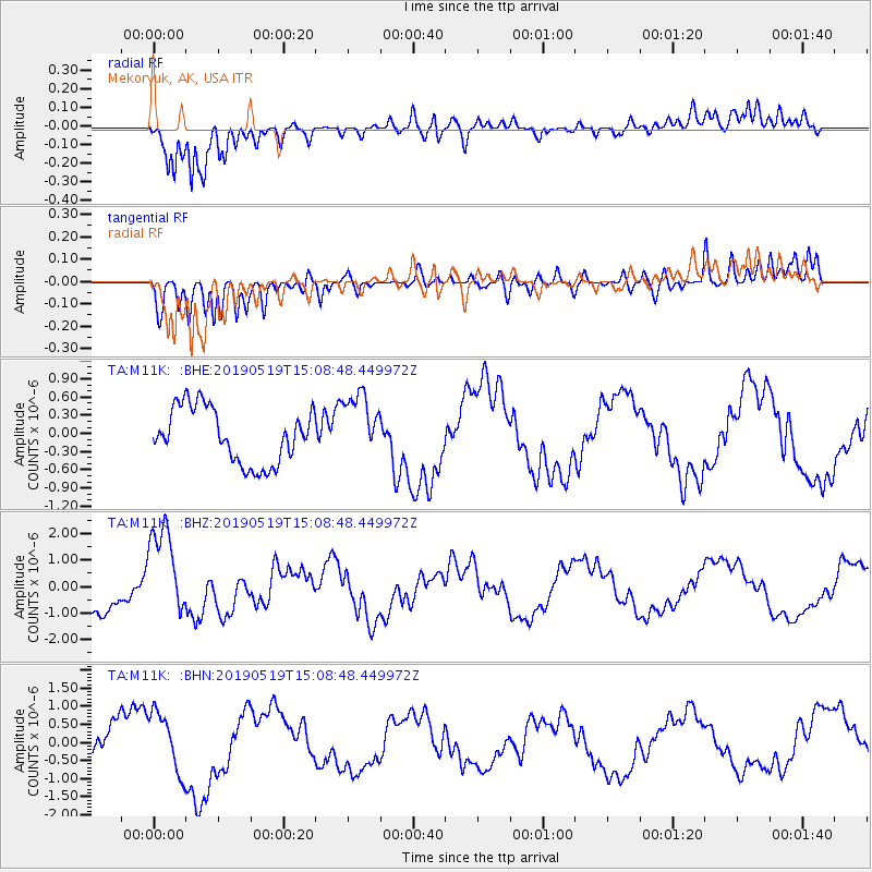
M11K Mekoryuk, AK, USA - Earthquake Result Viewer
*The percent match for this event was below the threshold and hence no stack was calculated.
| Earthquake location: |
Southeast Of Loyalty Islands |
| Earthquake latitude/longitude: |
-21.6/169.5 |
| Earthquake time(UTC): |
2019/05/19 (139) 14:56:50 GMT |
| Earthquake Depth: |
20 km |
| Earthquake Magnitude: |
6.3 mww |
| Earthquake Catalog/Contributor: |
NEIC PDE/us |
|
| Network: |
TA USArray Transportable Network (new EarthScope stations) |
| Station: |
M11K Mekoryuk, AK, USA |
| Lat/Lon: |
60.38 N/166.20 W |
| Elevation: |
3.0 m |
|
| Distance: |
84.1 deg |
| Az: |
11.872 deg |
| Baz: |
202.672 deg |
| Ray Param: |
$rayparam |
*The percent match for this event was below the threshold and hence was not used in the summary stack. |
|
| Radial Match: |
88.42745 % |
| Radial Bump: |
400 |
| Transverse Match: |
64.52574 % |
| Transverse Bump: |
400 |
| SOD ConfigId: |
18369291 |
| Insert Time: |
2019-06-02 15:01:41.165 +0000 |
| GWidth: |
2.5 |
| Max Bumps: |
400 |
| Tol: |
0.001 |
|
Signal To Noise
| Channel | StoN | STA | LTA |
| TA:M11K: :BHZ:20190519T15:08:48.449972Z | 2.8270943 | 1.7769212E-6 | 6.285327E-7 |
| TA:M11K: :BHN:20190519T15:08:48.449972Z | 1.6409364 | 8.219455E-7 | 5.009003E-7 |
| TA:M11K: :BHE:20190519T15:08:48.449972Z | 1.2039682 | 5.4656823E-7 | 4.5397235E-7 |
| Arrivals |
| Ps | |
| PpPs | |
| PsPs/PpSs | |


