You are here: Home > Network List > TA - USArray Transportable Network (new EarthScope stations) Stations List
> Station N21A Black Mountain, Craig, CO, USA > Earthquake Result Viewer
N21A Black Mountain, Craig, CO, USA - Earthquake Result Viewer
| Earthquake location: |
Samoa Islands Region |
| Earthquake latitude/longitude: |
-15.2/-172.6 |
| Earthquake time(UTC): |
2009/08/30 (242) 14:51:32 GMT |
| Earthquake Depth: |
11 km |
| Earthquake Magnitude: |
6.4 MB, 6.3 MS, 6.6 MW, 6.6 MW |
| Earthquake Catalog/Contributor: |
WHDF/NEIC |
|
| Network: |
TA USArray Transportable Network (new EarthScope stations) |
| Station: |
N21A Black Mountain, Craig, CO, USA |
| Lat/Lon: |
40.76 N/107.52 W |
| Elevation: |
2235 m |
|
| Distance: |
82.0 deg |
| Az: |
44.071 deg |
| Baz: |
242.12 deg |
| Ray Param: |
0.047207277 |
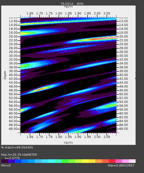
| Estimated Moho Depth: |
20.25 km |
| Estimated Crust Vp/Vs: |
2.08 |
| Assumed Crust Vp: |
6.159 km/s |
| Estimated Crust Vs: |
2.964 km/s |
| Estimated Crust Poisson's Ratio: |
0.35 |
|
| Radial Match: |
89.054405 % |
| Radial Bump: |
400 |
| Transverse Match: |
88.09772 % |
| Transverse Bump: |
400 |
| SOD ConfigId: |
2622 |
| Insert Time: |
2010-03-06 22:45:14.319 +0000 |
| GWidth: |
2.5 |
| Max Bumps: |
400 |
| Tol: |
0.001 |
|

Signal To Noise
| Channel | StoN | STA | LTA |
| TA:N21A: :BHN:20090830T15:03:21.225022Z | 32.00249 | 5.20446E-6 | 1.6262673E-7 |
| TA:N21A: :BHE:20090830T15:03:21.225022Z | 1.59787 | 3.563476E-7 | 2.2301414E-7 |
| TA:N21A: :BHZ:20090830T15:03:21.225022Z | 6.573649 | 1.3178721E-6 | 2.0047803E-7 |
| Arrivals |
| Ps | 3.6 SECOND |
| PpPs | 9.9 SECOND |
| PsPs/PpSs | 14 SECOND |


