You are here: Home > Network List > IU - Global Seismograph Network (GSN - IRIS/USGS) Stations List
> Station PAYG Puerto Ayora, Galapagos Islands > Earthquake Result Viewer
PAYG Puerto Ayora, Galapagos Islands - Earthquake Result Viewer
| Earthquake location: |
Chile-Argentina Border Region |
| Earthquake latitude/longitude: |
-35.1/-71.0 |
| Earthquake time(UTC): |
2016/11/04 (309) 16:20:43 GMT |
| Earthquake Depth: |
91 km |
| Earthquake Magnitude: |
6.4 MWP, 6.4 MWW |
| Earthquake Catalog/Contributor: |
NEIC PDE/NEIC COMCAT |
|
| Network: |
IU Global Seismograph Network (GSN - IRIS/USGS) |
| Station: |
PAYG Puerto Ayora, Galapagos Islands |
| Lat/Lon: |
0.67 S/90.29 W |
| Elevation: |
270 m |
|
| Distance: |
38.7 deg |
| Az: |
328.101 deg |
| Baz: |
154.323 deg |
| Ray Param: |
0.07512125 |
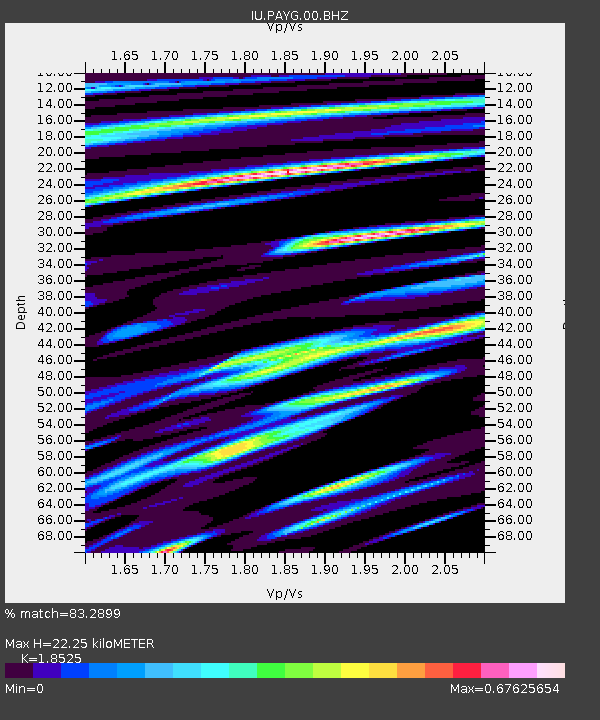
| Estimated Moho Depth: |
22.25 km |
| Estimated Crust Vp/Vs: |
1.85 |
| Assumed Crust Vp: |
4.802 km/s |
| Estimated Crust Vs: |
2.592 km/s |
| Estimated Crust Poisson's Ratio: |
0.29 |
|
| Radial Match: |
83.2899 % |
| Radial Bump: |
400 |
| Transverse Match: |
68.715096 % |
| Transverse Bump: |
393 |
| SOD ConfigId: |
1815711 |
| Insert Time: |
2016-11-18 16:24:42.864 +0000 |
| GWidth: |
2.5 |
| Max Bumps: |
400 |
| Tol: |
0.001 |
|
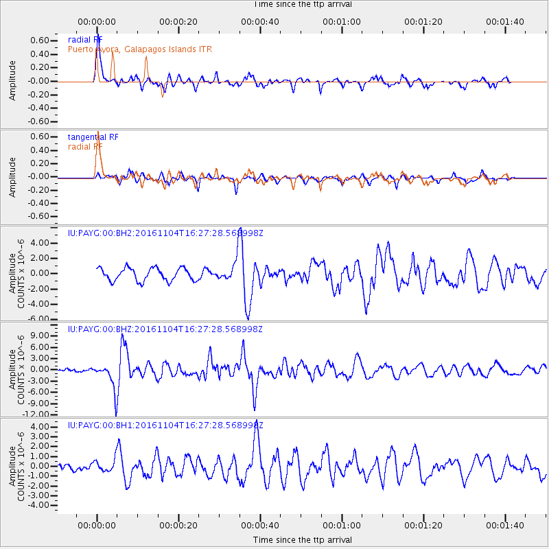
Signal To Noise
| Channel | StoN | STA | LTA |
| IU:PAYG:00:BHZ:20161104T16:27:28.568998Z | 8.857682 | 3.7325738E-6 | 4.2139396E-7 |
| IU:PAYG:00:BH1:20161104T16:27:28.568998Z | 1.4840575 | 6.6971717E-7 | 4.5127442E-7 |
| IU:PAYG:00:BH2:20161104T16:27:28.568998Z | 1.995677 | 1.6408212E-6 | 8.2218776E-7 |
| Arrivals |
| Ps | 4.1 SECOND |
| PpPs | 13 SECOND |
| PsPs/PpSs | 17 SECOND |


