You are here: Home > Network List > TA - USArray Transportable Network (new EarthScope stations) Stations List
> Station N21A Black Mountain, Craig, CO, USA > Earthquake Result Viewer
N21A Black Mountain, Craig, CO, USA - Earthquake Result Viewer

| Earthquake location: |
North Of Honduras |
| Earthquake latitude/longitude: |
16.7/-86.2 |
| Earthquake time(UTC): |
2009/05/28 (148) 08:24:45 GMT |
| Earthquake Depth: |
10 km |
| Earthquake Magnitude: |
6.7 MB, 7.2 MS, 7.3 MW, 7.3 MW |
| Earthquake Catalog/Contributor: |
WHDF/NEIC |
|
| Network: |
TA USArray Transportable Network (new EarthScope stations) |
| Station: |
N21A Black Mountain, Craig, CO, USA |
| Lat/Lon: |
40.76 N/107.52 W |
| Elevation: |
2235 m |
|
| Distance: |
30.2 deg |
| Az: |
326.765 deg |
| Baz: |
136.259 deg |
| Ray Param: |
0.07939238 |
| Estimated Moho Depth: |
10.0 km |
| Estimated Crust Vp/Vs: |
1.60 |
| Assumed Crust Vp: |
6.159 km/s |
| Estimated Crust Vs: |
3.849 km/s |
| Estimated Crust Poisson's Ratio: |
0.18 |
|
| Radial Match: |
91.395454 % |
| Radial Bump: |
400 |
| Transverse Match: |
88.38964 % |
| Transverse Bump: |
400 |
| SOD ConfigId: |
2648 |
| Insert Time: |
2010-03-06 22:45:19.284 +0000 |
| GWidth: |
2.5 |
| Max Bumps: |
400 |
| Tol: |
0.001 |
|
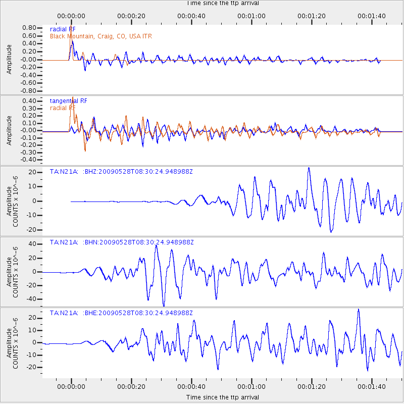
Signal To Noise
| Channel | StoN | STA | LTA |
| TA:N21A: :BHN:20090528T08:30:24.948988Z | 32.25562 | 2.4067251E-6 | 7.4614135E-8 |
| TA:N21A: :BHE:20090528T08:30:24.948988Z | 4.778844 | 7.433348E-7 | 1.5554699E-7 |
| TA:N21A: :BHZ:20090528T08:30:24.948988Z | 6.881539 | 7.9925644E-7 | 1.1614502E-7 |
| Arrivals |
| Ps | 1.1 SECOND |
| PpPs | 3.9 SECOND |
| PsPs/PpSs | 4.9 SECOND |


