You are here: Home > Network List > TA - USArray Transportable Network (new EarthScope stations) Stations List
> Station N21A Black Mountain, Craig, CO, USA > Earthquake Result Viewer
N21A Black Mountain, Craig, CO, USA - Earthquake Result Viewer
| Earthquake location: |
Kuril Islands |
| Earthquake latitude/longitude: |
46.0/151.5 |
| Earthquake time(UTC): |
2009/04/07 (097) 04:23:33 GMT |
| Earthquake Depth: |
31 km |
| Earthquake Magnitude: |
6.5 MB, 6.8 MS, 6.9 MW, 6.9 MW |
| Earthquake Catalog/Contributor: |
WHDF/NEIC |
|
| Network: |
TA USArray Transportable Network (new EarthScope stations) |
| Station: |
N21A Black Mountain, Craig, CO, USA |
| Lat/Lon: |
40.76 N/107.52 W |
| Elevation: |
2235 m |
|
| Distance: |
68.5 deg |
| Az: |
53.28 deg |
| Baz: |
312.7 deg |
| Ray Param: |
0.056212194 |
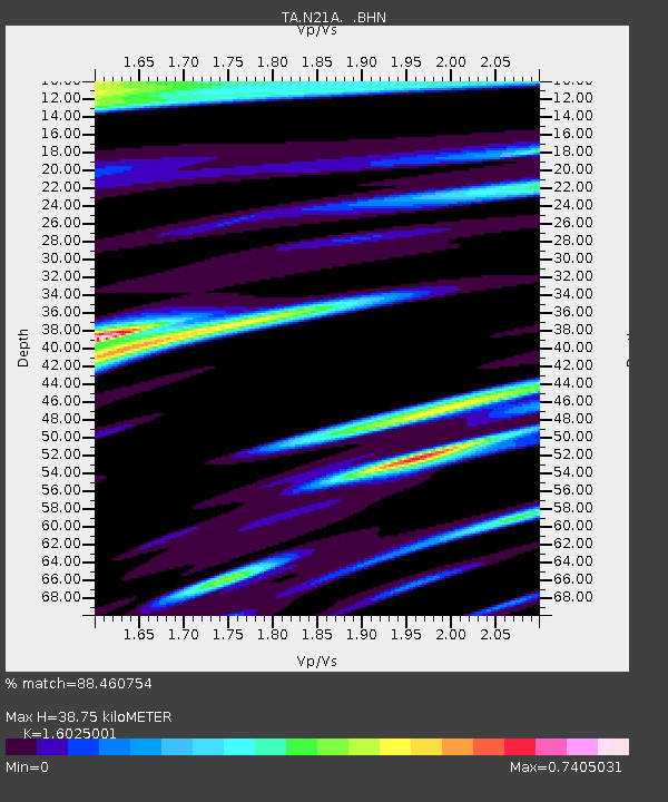
| Estimated Moho Depth: |
38.75 km |
| Estimated Crust Vp/Vs: |
1.60 |
| Assumed Crust Vp: |
6.159 km/s |
| Estimated Crust Vs: |
3.843 km/s |
| Estimated Crust Poisson's Ratio: |
0.18 |
|
| Radial Match: |
88.460754 % |
| Radial Bump: |
400 |
| Transverse Match: |
74.55654 % |
| Transverse Bump: |
400 |
| SOD ConfigId: |
2658 |
| Insert Time: |
2010-03-06 22:45:30.345 +0000 |
| GWidth: |
2.5 |
| Max Bumps: |
400 |
| Tol: |
0.001 |
|

Signal To Noise
| Channel | StoN | STA | LTA |
| TA:N21A: :BHN:20090407T04:34:01.550024Z | 25.664406 | 5.129421E-6 | 1.9986518E-7 |
| TA:N21A: :BHE:20090407T04:34:01.550024Z | 2.3614726 | 1.1689481E-6 | 4.950081E-7 |
| TA:N21A: :BHZ:20090407T04:34:01.550024Z | 3.026509 | 1.7865613E-6 | 5.903043E-7 |
| Arrivals |
| Ps | 3.9 SECOND |
| PpPs | 16 SECOND |
| PsPs/PpSs | 20 SECOND |


