You are here: Home > Network List > UO - University of Oregon Regional Network Stations List
> Station WLOO Lebanon, OR, USA > Earthquake Result Viewer
WLOO Lebanon, OR, USA - Earthquake Result Viewer
| Earthquake location: |
Southeast Of Loyalty Islands |
| Earthquake latitude/longitude: |
-21.6/169.5 |
| Earthquake time(UTC): |
2019/05/19 (139) 14:56:50 GMT |
| Earthquake Depth: |
20 km |
| Earthquake Magnitude: |
6.3 mww |
| Earthquake Catalog/Contributor: |
NEIC PDE/us |
|
| Network: |
UO University of Oregon Regional Network |
| Station: |
WLOO Lebanon, OR, USA |
| Lat/Lon: |
44.52 N/122.74 W |
| Elevation: |
284 m |
|
| Distance: |
90.2 deg |
| Az: |
41.473 deg |
| Baz: |
239.492 deg |
| Ray Param: |
0.04168562 |
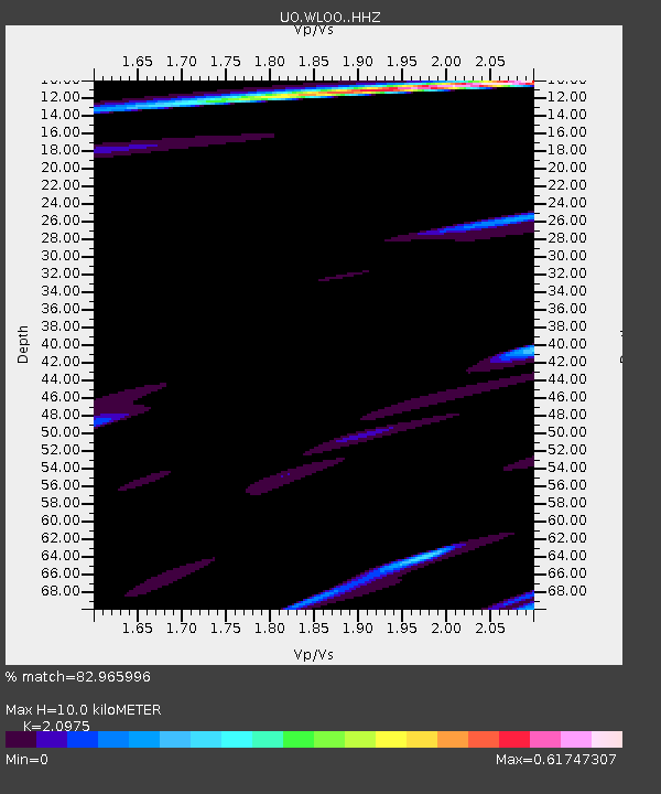
| Estimated Moho Depth: |
10.0 km |
| Estimated Crust Vp/Vs: |
2.10 |
| Assumed Crust Vp: |
6.566 km/s |
| Estimated Crust Vs: |
3.13 km/s |
| Estimated Crust Poisson's Ratio: |
0.35 |
|
| Radial Match: |
82.965996 % |
| Radial Bump: |
400 |
| Transverse Match: |
65.94844 % |
| Transverse Bump: |
400 |
| SOD ConfigId: |
18369291 |
| Insert Time: |
2019-06-02 15:02:26.815 +0000 |
| GWidth: |
2.5 |
| Max Bumps: |
400 |
| Tol: |
0.001 |
|

Signal To Noise
| Channel | StoN | STA | LTA |
| UO:WLOO: :HHZ:20190519T15:09:18.297995Z | 1.7223989 | 1.1635108E-6 | 6.755176E-7 |
| UO:WLOO: :HHN:20190519T15:09:18.297995Z | 1.1463851 | 5.256068E-7 | 4.5849063E-7 |
| UO:WLOO: :HHE:20190519T15:09:18.297995Z | 0.8871881 | 5.0192284E-7 | 5.657457E-7 |
| Arrivals |
| Ps | 1.7 SECOND |
| PpPs | 4.6 SECOND |
| PsPs/PpSs | 6.3 SECOND |


