You are here: Home > Network List > IU - Global Seismograph Network (GSN - IRIS/USGS) Stations List
> Station WVT Waverly, Tennessee, USA > Earthquake Result Viewer
WVT Waverly, Tennessee, USA - Earthquake Result Viewer

| Earthquake location: |
Chile-Argentina Border Region |
| Earthquake latitude/longitude: |
-35.1/-71.0 |
| Earthquake time(UTC): |
2016/11/04 (309) 16:20:43 GMT |
| Earthquake Depth: |
91 km |
| Earthquake Magnitude: |
6.4 MWP, 6.4 MWW |
| Earthquake Catalog/Contributor: |
NEIC PDE/NEIC COMCAT |
|
| Network: |
IU Global Seismograph Network (GSN - IRIS/USGS) |
| Station: |
WVT Waverly, Tennessee, USA |
| Lat/Lon: |
36.13 N/87.83 W |
| Elevation: |
170 m |
|
| Distance: |
72.6 deg |
| Az: |
345.776 deg |
| Baz: |
165.59 deg |
| Ray Param: |
0.053351447 |
| Estimated Moho Depth: |
36.5 km |
| Estimated Crust Vp/Vs: |
2.00 |
| Assumed Crust Vp: |
6.444 km/s |
| Estimated Crust Vs: |
3.218 km/s |
| Estimated Crust Poisson's Ratio: |
0.33 |
|
| Radial Match: |
94.30989 % |
| Radial Bump: |
400 |
| Transverse Match: |
84.65032 % |
| Transverse Bump: |
400 |
| SOD ConfigId: |
1815711 |
| Insert Time: |
2016-11-18 16:25:16.015 +0000 |
| GWidth: |
2.5 |
| Max Bumps: |
400 |
| Tol: |
0.001 |
|
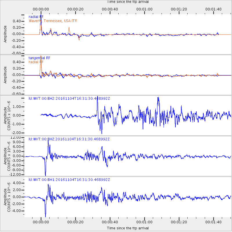
Signal To Noise
| Channel | StoN | STA | LTA |
| IU:WVT:00:BHZ:20161104T16:31:30.468992Z | 33.497982 | 4.4741087E-6 | 1.3356353E-7 |
| IU:WVT:00:BH1:20161104T16:31:30.468992Z | 16.401934 | 1.8920013E-6 | 1.15352336E-7 |
| IU:WVT:00:BH2:20161104T16:31:30.468992Z | 6.6106944 | 7.776376E-7 | 1.1763327E-7 |
| Arrivals |
| Ps | 5.9 SECOND |
| PpPs | 16 SECOND |
| PsPs/PpSs | 22 SECOND |


